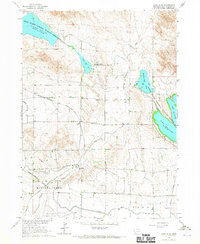
1965 Map of Lake Alice
USGS Topo · Published 1967About this map
The North Platte National Wildlife Refuge dominates this western Nebraska landscape, centered on the critical water management systems of Lake Alice and Lake Minatare. In this mid-century period, the area exhibits a highly engineered agricultural environment, where the Tri-State Canal, Supply Canal, and various laterals move water across the plains of Funston and Dewey. This irrigation network is the lifeblood of the local economy, supporting scattered operations like Gueck Ranch and the small station at James.
Find a feature on this map
32 named features on this map. Tap any name to fly to it.
Don’t see what you’re looking for? This feature index may not catch every label — zoom into the map to look around manually.
Map Details
Editions of this 1965 Lake Alice Map
This is the sole edition of this map. No revisions or reprints were ever made.
Other maps of this area

1898 · Scotts Bluff
USGS Topo · 1:125,000

1898 · Camp Clarke
USGS Topo · 1:125,000

1899 · Whistle Creek
USGS Topo · 1:125,000

1951 · Kilpatrick Lake
USGS Topo · 1:62,500

1954 · Scottsbluff
USGS Topo · 1:250,000

1955 · Alliance
USGS Topo · 1:250,000

1957 · Alliance
USGS Topo · 1:250,000

1958 · Alliance
USGS Topo · 1:250,000

1958 · Scottsbluff
USGS Topo · 1:250,000

1963 · Scottsbluff South
USGS Topo · 1:24,000