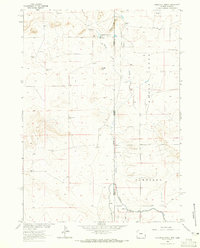
1963 Map of Carpenter Ranch
USGS Topo · Published 1965About this map
The high plains of the Wyoming-Nebraska border define this mid-century survey, where the arid landscape is marked by the critical infrastructure of western ranching. Central to the area is the Carpenter Ranch and its nearby Carpenter Reservoir No 1, which manages water alongside the Interstate Canal and Lateral No 4. The reliance on groundwater is evident through a network of family-named landmarks like the Milligan Windmill, Wildy Windmill, and Furnal Windmill, which served as vital points for livestock in this high-elevation terrain. Settlement patterns are sparse, represented by locations such as James and the Duncan Place. Significant geographical features like Coyote Hill and the winding course of Sheep Creek provide the primary relief in a territory largely organized by the township and range system near the Goshen and Sioux County line.
Find a feature on this map
26 named features on this map. Tap any name to fly to it.
Don’t see what you’re looking for? This feature index may not catch every label — zoom into the map to look around manually.
Map Details
Editions of this 1963 Carpenter Ranch Map
2 editions found
Other maps of this area

1896 · Patrick
USGS Topo · 1:125,000

1899 · Whistle Creek
USGS Topo · 1:125,000

1954 · Torrington
USGS Topo · 1:250,000

1955 · Alliance
USGS Topo · 1:250,000

1957 · Alliance
USGS Topo · 1:250,000

1958 · Torrington
USGS Topo · 1:250,000

1958 · Alliance
USGS Topo · 1:250,000

1963 · Chalk Buttes
USGS Topo · 1:24,000
1963 · Torrington SE
USGS Topo · 1:24,000

1963 · Tea Kettle Rock
USGS Topo · 1:24,000