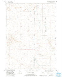
1963 Map of Carpenter Ranch
USGS Topo · Published 1993About this map
Carpenter Ranch serves as a primary landmark in this high-plains landscape where the Goshen Co Sioux Co line meets the Wyoming Nebraska state border. The terrain is defined by a series of ranching improvements and water-management features, including the Carpenter Reservoir No 1 and its associated spillway, along with a complex network of unnamed trails and irrigation infrastructure like Canal and Lateral No 4. The map reveals a highly localized dependence on groundwater, marked by numerous family-named and site-specific pumping stations such as Massey Windmill, Wildy Windmill, and Nash Windmill. These dispersed features, set against the backdrop of Coyote Hill and Indian River Hill, highlight the sparse but deliberate settlement pattern typical of the region's agricultural history during the mid-to-late twentieth century.
Find a feature on this map
23 named features on this map. Tap any name to fly to it.
Don’t see what you’re looking for? This feature index may not catch every label — zoom into the map to look around manually.
Map Details
Editions of this 1963 Carpenter Ranch Map
2 editions found
Other maps of this area

1896 · Patrick
USGS Topo · 1:125,000

1899 · Whistle Creek
USGS Topo · 1:125,000

1954 · Torrington
USGS Topo · 1:250,000

1955 · Alliance
USGS Topo · 1:250,000

1957 · Alliance
USGS Topo · 1:250,000

1958 · Torrington
USGS Topo · 1:250,000

1958 · Alliance
USGS Topo · 1:250,000

1963 · Chalk Buttes
USGS Topo · 1:24,000
1963 · Torrington SE
USGS Topo · 1:24,000

1963 · Tea Kettle Rock
USGS Topo · 1:24,000