1940s Maps of Thomas County, Nebraska
Explore 7 historic maps of Thomas County from the 1940s. These maps offer a rare glimpse into what life looked like during the 1940s — showing old roads, neighborhoods, homes, and landmarks that have changed or disappeared over time.
Whether you're researching your family's past, planning a metal detecting trip, or studying how Thomas County's landscape evolved across the 1940s, these high-resolution maps are a powerful tool for exploring the history of this region.
- Focus on a specific era: All maps on this page are from the 1940s, giving you a focused view of this time period.
- See what’s changed: Compare century-old streets, trails, and buildings to today's modern landscape using overlays and satellite layers.
- Research with precision: Use these maps for genealogy, historical research, land use analysis, or educational projects.
- View, download, or print: Maps are fully viewable online in high resolution, and can be downloaded or printed for your own records.
Start exploring Thomas County's history through authentic maps from the 1940s. This is your window into the past.
Thomas County, NE maps
(7)- 1948 Map of Seneca, 1956 Print
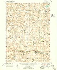 1948 Seneca1956 Print · USGSThe Middle Loup River valley in the late 1940s served as a lifeline for ranching and rail. Genealogists can trace family-named landmarks like Phillips Ranch and Simonson and Lowe Ranch or locate the old Virginia Sch.3 unique versions available
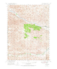
 - 1948 Map of Thedford, 1963 Print
 1948 Thedford1963 Print · USGSThedford and the surrounding Sandhills appear here shortly after the war, showing the rail-and-river network that defined Thomas County. Researchers can locate family-named landmarks like Warner Bridge and rural schools including Ewoldt Sch and Albright Sch.
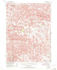
 - 1948 Map of Halsey, 1973 Print
 1948 Halsey1973 Print · USGSThomas and Blaine counties appear in the late 1940s as a landscape of forest plantations and river valleys. Researchers can trace the ranching economy and forest infrastructure via Halsey, the Scott Lookout Tower, and the Rose Hill Sch.
 - 1948 Map of Seneca 4, 1974 Print
 1948 Seneca 41974 Print · USGSThe Nebraska Sand Hills and the Cherry County border come to life in the late 1940s, showing the intersection of rail transit and rural ranching. Genealogists can trace family roots through the locations of Eatinger Sch, School No 9, and the settlement at Norway.
 - 1949 Map of Seneca 4
 1949 Seneca 41949 Print · USGSThe Nebraska Sandhills in the late 1940s reveal a landscape of isolated ranching outposts and river-valley transport. Genealogists and local historians can trace the foundations of rural life through Eatinger Sch, the settlement of Norway, and the Middle Loup River rail corridor.
 - 1949 Map of Purdum, 1967 Print
 1949 Purdum1967 Print · USGSThe Nebraska Sandhills come into focus in the late 1940s as a region of remote ranching outposts and high prairie rivers. Researchers can locate dozens of historic family lands like the McMullen Ranch and Atkinson Ranch, or trace the rural school system through West Purdum Sch and Compton Sch.
 - 1949 Map of Cody Lake, 1972 Print
 1949 Cody Lake1972 Print · USGSThe ranching country of central Nebraska is captured here just after the war, showing the scattered homesteads and rural schoolhouses of the Sandhills. Genealogists can locate specific family lands including the Pfeiffer Ranch and Viehmeyer Ranch or trace local education at Lone Valley Sch.
End of results
Showing maps 1-7 of 7
Top cities of Thomas County
Frequently asked questions
- What are the different types of historical maps available for Thomas County?
- What is the oldest map of Thomas County?
- Where can I purchase historical maps of Thomas County for my home or office?
- Where can I download high-res historical maps of Thomas County?
- Are there historical topographic maps available for Thomas County?
- Is there historical aerial imagery available for Thomas County?
- Where are historical maps of Thomas County sourced from?