1960s Maps of York, Nebraska
Explore 3 historic maps of York from the 1960s. These maps offer a rare glimpse into what life looked like during the 1960s — showing old roads, neighborhoods, homes, and landmarks that have changed or disappeared over time.
Whether you're researching your family's past, planning a metal detecting trip, or studying how York's landscape evolved across the 1960s, these high-resolution maps are a powerful tool for exploring the history of this region.
- Focus on a specific era: All maps on this page are from the 1960s, giving you a focused view of this time period.
- See what’s changed: Compare century-old streets, trails, and buildings to today's modern landscape using overlays and satellite layers.
- Research with precision: Use these maps for genealogy, historical research, land use analysis, or educational projects.
- View, download, or print: Maps are fully viewable online in high resolution, and can be downloaded or printed for your own records.
Start exploring York's history through authentic maps from the 1960s. This is your window into the past.
York, NE maps
(3)- 1969 Map of York North, 1971 Print
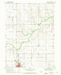 1969 York North1971 Print · USGSYork and the surrounding plains of central Nebraska are shown here in the late sixties as the town expanded into a regional hub. Researchers can trace family roots at Rosemond Cem or locate vanished landmarks like Edison Sch and the Drive-in Theater.2 unique versions available
 - 1969 Map of Bradshaw, 1971 Print
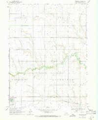 1969 Bradshaw1971 Print · USGSBradshaw and the surrounding York County farmlands are captured in the late sixties as the regional rail economy thrived. Trace family roots and land use near Bradshaw and local landmarks like Lincoln Creek Cem and the Burlington Northern line.
 - 1969 Map of York South, 1971 Print
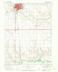 1969 York South1971 Print · USGSThe city of York and its surrounding farm townships are captured here in the late sixties, showing a landscape defined by agriculture and rail. Genealogists can trace family names through rural landmarks like Vernon Cem Townhall, St Josephs Sch, and the Burlington Northern line.
End of results
Showing maps 1-3 of 3
Top cities near York
- Henderson historical maps
- Exeter historical maps
- Fairmont historical maps
- McCool Junction historical maps
- Bradshaw historical maps
- Polk historical maps
See more
Frequently asked questions
- What are the different types of historical maps available for York?
- What is the oldest map of York?
- Where can I purchase historical maps of York for my home or office?
- Where can I download high-res historical maps of York?
- Are there historical topographic maps available for York?
- Is there historical aerial imagery available for York?
- Where are historical maps of York sourced from?