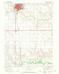
1969 Map of York South
USGS Topo · Published 1971About this map
York dominates the northern edge of this Nebraska landscape, serving as a concentrated hub of civic and educational life in the late 1960s. The city's grid is dense with landmarks like the Courthouse, City Hall, and several specialized schools including Emmanuel Sch and Willard Sch. Beyond the city limits, the terrain transitions into a highly organized agricultural expanse, defined by the township divisions of Lockridge, Baker, Leroy, Hays, and McFadden. Transport corridors are prominent, with the Burlington Northern railroad and Highway 81 cutting north-south through the plains.
Find a feature on this map
40 named features on this map. Tap any name to fly to it.
Don’t see what you’re looking for? This feature index may not catch every label — zoom into the map to look around manually.
Map Details
Editions of this 1969 York South Map
This is the sole edition of this map. No revisions or reprints were ever made.
Other maps of this area

1898 · York
USGS Topo · 1:125,000

1899 · York
USGS Topo · 1:125,000

1934 · Utica
USGS Topo · 1:62,500

1937 · Utica
USGS Topo · 1:62,500

1955 · Lincoln
USGS Topo · 1:250,000

1957 · Lincoln
USGS Topo · 1:250,000

1958 · Lincoln
USGS Topo · 1:250,000
1969 · York North
USGS Topo · 1:24,000
1969 · Utica SW
USGS Topo · 1:24,000

1969 · Fairmont
USGS Topo · 1:24,000