1900s (20th Century) Maps of Fallon, Nevada
Explore 10 historic maps of Fallon from the 1900s (20th Century). These maps offer a rare glimpse into what life looked like during the 1900s — showing old roads, neighborhoods, homes, and landmarks that have changed or disappeared over time.
Whether you're researching your family's past, planning a metal detecting trip, or studying how Fallon's landscape evolved across the 1900s, these high-resolution maps are a powerful tool for exploring the history of this region.
- Focus on a specific era: All maps on this page are from the 1900s, giving you a focused view of this time period.
- See what’s changed: Compare century-old streets, trails, and buildings to today's modern landscape using overlays and satellite layers.
- Research with precision: Use these maps for genealogy, historical research, land use analysis, or educational projects.
- View, download, or print: Maps are fully viewable online in high resolution, and can be downloaded or printed for your own records.
Start exploring Fallon's history through authentic maps from the 1900s. This is your window into the past.
Fallon, NV maps
(10)- 1908 Map of Carson Sink, 1954 Print
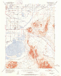
 1908 Carson Sink1954 Print · USGSChurchill County at the opening of the century reveals a landscape of desert mining camps and nascent river irrigation. Genealogists and historians can trace the early streets of Fallon, the remote Nevada Hills Mine, and the location of Dixie.3 unique versions available
 - 1910 Map of Carson Sink
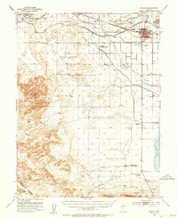
 1910 Carson Sink1910 Print · USGSWestern Nevada at the end of the first decade of the century shows a landscape defined by desert mining camps and the burgeoning Carson-Truckee irrigation projects. Genealogists and historians can trace the early streets of Fallon or locate remote camps like Rawhide and the Nevada Wonder Mine.5 unique versions available
 - 1951 Map of Carson Lake, 1953 Print
 1951 Carson Lake1953 Print · USGSChurchill County in the early fifties shows a transition from high-desert flats to complex irrigation projects and military installations. Genealogists and historians can trace the Harmon School, Fallen Cem, and several named archaeological sites like Hidden Cave.3 unique versions available
 - 1951 Map of Fallon, 1953 Print
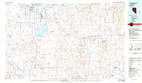
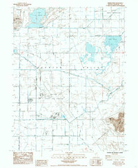
 1951 Fallon1953 Print · USGSFallon and the surrounding Lahontan Valley are captured here in the early fifties as irrigation and ranching redefined the high desert. Researchers can trace historic rural education and transport, from the Oats Park Sch to the legendary Pony Express Route and Smith Ranch.3 unique versions available
 - 1957 Map of Reno, 1963 Print
 1957 Reno1963 Print · USGSWestern Nevada in the early sixties is a land of sprawling desert sinks and rising mountain ranges. Genealogists and historians can trace the rail-and-river network connecting Reno, the mining legacy of Rawhide Mine, and the boundaries of the Pyramid Lake Indian Reservation.5 unique versions available
 - 1959 Map of Reno
 1959 Reno1959 Print · USGSWestern Nevada in the late fifties was a land of expanding military airbases and high-desert irrigation projects. You can trace the lineage of the Comstock era through Carson City, locate the Pony Express Monument, or study the rail networks of the Southern Pacific RR.
 - 1960 Map of Reno
 1960 Reno1960 Print · USGSThe high desert of western Nevada comes alive in this mid-century survey of the Reno-Tahoe region. Genealogists and historians can trace rail lines like the Southern Pacific RR and locate remote outposts such as Olinghouse, Nixon, and the Olinghouse Mine.2 unique versions available
 - 1979 Map of Fallon, 1980 Print
 1979 Fallon1980 Print · USGSIn the Great Basin during the late seventies, the agricultural life of the Lahontan Valley meets a sprawling landscape of naval reservations and desert ranges. Genealogists and researchers can locate remote outposts like Frenchman, industrial sites at the Summit King Mine, and the historic Southern Pacific rail line.2 unique versions available
 - 1985 Map of Fallon
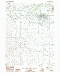 1985 Fallon1985 Print · USGSThe high desert landscape of central Nevada is captured here during the mid-eighties, showing the irrigation-dependent growth of the Fallon area. Genealogists can locate the Indian Colony and St Clair, while tracing landmarks like the St Clair Cem and Southern Pacific line.2 unique versions available
 - 1985 Map of Grimes Point
 1985 Grimes Point1985 Print · USGSThe Lahontan Valley in the mid-1980s shows a unique transition from the irrigated fields of Harmon Reservoir to the high-tech expanse of Fallon Naval Air Station. Researchers can trace rural family sites like the Harmon School or explore landmarks at Grimes Point and Rattlesnake Hill.
End of results
Showing maps 1-10 of 10
Top cities near Fallon
Frequently asked questions
- What are the different types of historical maps available for Fallon?
- What is the oldest map of Fallon?
- Where can I purchase historical maps of Fallon for my home or office?
- Where can I download high-res historical maps of Fallon?
- Are there historical topographic maps available for Fallon?
- Is there historical aerial imagery available for Fallon?
- Where are historical maps of Fallon sourced from?