1960s Maps of Las Vegas, Nevada
Explore 3 historic maps of Las Vegas from the 1960s. These maps offer a rare glimpse into what life looked like during the 1960s — showing old roads, neighborhoods, homes, and landmarks that have changed or disappeared over time.
Whether you're researching your family's past, planning a metal detecting trip, or studying how Las Vegas's landscape evolved across the 1960s, these high-resolution maps are a powerful tool for exploring the history of this region.
- Focus on a specific era: All maps on this page are from the 1960s, giving you a focused view of this time period.
- See what’s changed: Compare century-old streets, trails, and buildings to today's modern landscape using overlays and satellite layers.
- Research with precision: Use these maps for genealogy, historical research, land use analysis, or educational projects.
- View, download, or print: Maps are fully viewable online in high resolution, and can be downloaded or printed for your own records.
Start exploring Las Vegas's history through authentic maps from the 1960s. This is your window into the past.
Las Vegas, NV maps
(3)- 1962 Map of Las Vegas
 1962 Las Vegas1962 Print · USGSSouthern Nevada is captured here during a period of significant military and industrial growth in the early sixties. Researchers can trace the development of Las Vegas alongside the Magnesium Plant in Henderson and the expansive Nellis Air Force Base.
 - 1967 Map of Las Vegas NW, 1968 Print
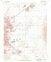
 1967 Las Vegas NW1968 Print · USGSMid-century Nevada comes alive in this survey of the desert metropolis during its rapid post-war expansion. Local historians can trace the foundations of modern neighborhoods through dozens of schools like Culley Sch and landmarks such as the North Las Vegas Air Terminal.6 unique versions available
 - 1967 Map of Las Vegas NE, 1968 Print
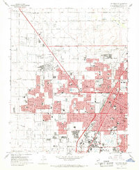
 1967 Las Vegas NE1968 Print · USGSGreater Las Vegas undergoes rapid suburban expansion in the late sixties, with residential grids reaching toward the desert foothills. Researchers can trace the mid-century city layout through Sunrise Acres, the Frenchman Mine, and dozens of local schools.6 unique versions available
End of results
Showing maps 1-3 of 3
Top cities near Las Vegas
- Henderson historical maps
- North Las Vegas historical maps
- Enterprise historical maps
- Spring Valley historical maps
- Sunrise Manor historical maps
- Paradise historical maps
See more
Top neighborhoods of Las Vegas
- Lower Kyle Canyon historical maps
- Summerlin West historical maps
- East Las Vegas historical maps
- Five Points historical maps
- Twin Lakes historical maps
- West Las Vegas historical maps
See more
Frequently asked questions
- What are the different types of historical maps available for Las Vegas?
- What is the oldest map of Las Vegas?
- Where can I purchase historical maps of Las Vegas for my home or office?
- Where can I download high-res historical maps of Las Vegas?
- Are there historical topographic maps available for Las Vegas?
- Is there historical aerial imagery available for Las Vegas?
- Where are historical maps of Las Vegas sourced from?