1980s Maps of Elaine (site), Nevada
Explore 2 historic maps of Elaine (site) from the 1980s. These maps offer a rare glimpse into what life looked like during the 1980s — showing old roads, neighborhoods, homes, and landmarks that have changed or disappeared over time.
Whether you're researching your family's past, planning a metal detecting trip, or studying how Elaine (site)'s landscape evolved across the 1980s, these high-resolution maps are a powerful tool for exploring the history of this region.
- Focus on a specific era: All maps on this page are from the 1980s, giving you a focused view of this time period.
- See what’s changed: Compare century-old streets, trails, and buildings to today's modern landscape using overlays and satellite layers.
- Research with precision: Use these maps for genealogy, historical research, land use analysis, or educational projects.
- View, download, or print: Maps are fully viewable online in high resolution, and can be downloaded or printed for your own records.
Start exploring Elaine (site)'s history through authentic maps from the 1980s. This is your window into the past.
Elaine (site), NV maps
(2)- 1985 Map of Wendover
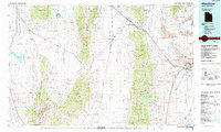 1985 Wendover1985 Print · USGSThe high desert borderlands of Utah and Nevada are captured here during the mid-eighties, dominated by vast salt flats and isolated mountain ranges. Researchers can trace the sprawling Wendover Air Force Auxiliary Field, old rail stops like Shafter, and remote workings at the Monarch Mine.
 - 1986 Map of Chase Spring
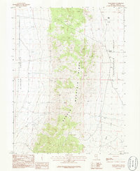 1986 Chase Spring1986 Print · USGSElko County, Nevada, is captured here in the mid-1980s as a high-desert landscape of ranching and mining. Trace the divide between Clover Valley and Independence Valley to find local landmarks like Chase Spring, Mound Springs, and multiple Prospect sites.
End of results
Showing maps 1-2 of 2
Frequently asked questions
- What are the different types of historical maps available for Elaine (site)?
- What is the oldest map of Elaine (site)?
- Where can I purchase historical maps of Elaine (site) for my home or office?
- Where can I download high-res historical maps of Elaine (site)?
- Are there historical topographic maps available for Elaine (site)?
- Is there historical aerial imagery available for Elaine (site)?
- Where are historical maps of Elaine (site) sourced from?