1900s (20th Century) Maps of Cordero, Nevada
Explore 5 historic maps of Cordero from the 1900s (20th Century). These maps offer a rare glimpse into what life looked like during the 1900s — showing old roads, neighborhoods, homes, and landmarks that have changed or disappeared over time.
Whether you're researching your family's past, planning a metal detecting trip, or studying how Cordero's landscape evolved across the 1900s, these high-resolution maps are a powerful tool for exploring the history of this region.
- Focus on a specific era: All maps on this page are from the 1900s, giving you a focused view of this time period.
- See what’s changed: Compare century-old streets, trails, and buildings to today's modern landscape using overlays and satellite layers.
- Research with precision: Use these maps for genealogy, historical research, land use analysis, or educational projects.
- View, download, or print: Maps are fully viewable online in high resolution, and can be downloaded or printed for your own records.
Start exploring Cordero's history through authentic maps from the 1900s. This is your window into the past.
Cordero, NV maps
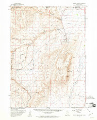
(5)- 1955 Map of McDermitt
 1955 McDermitt1955 Print · USGSNorthern Nevada in the mid-fifties shows a landscape of mining camps and vast cattle ranges. Trace the early footprints of Tuscarora or the remote Cordero Mine and National Mine tucked into the high desert peaks.3 unique versions available
 - 1959 Map of McDermitt
 1959 McDermitt1959 Print · USGSThe high-desert borderlands of northern Nevada and southern Oregon are captured here in the late fifties. Researchers can trace historic mining operations at the Cordero Mine and Getchell Mine, or locate settlements like Paradise Valley and Tuscarora.2 unique versions available
 - 1959 Map of Jordan Meadow, 1961 Print
 1959 Jordan Meadow1961 Print · USGSThe high desert along the Nevada-Oregon border comes alive in this late 1950s survey, showing the vital connection between water and settlement. Researchers can trace the industrial footprint of the Cordero Mine or locate the historic Ft Mc Dermitt Indian Res and Lucky Seven Ranch.2 unique versions available
 - 1985 Map of Quinn River Valley
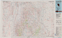 1985 Quinn River Valley1985 Print · USGSThe high desert along the Nevada and Oregon border in the mid-1980s reveals a land of remote ranching hubs and mountain mining. Genealogists and historians can trace the legacy of the Fort Mc Dermitt Indian Reservation or locate isolated sites like the Solid Silver Mine and Rebel.
 - 1991 Map of Cordero Mine
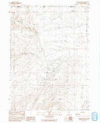 1991 Cordero Mine1991 Print · USGSHumboldt County ranching and mercury mining meet at the Nevada-Oregon border in the early nineties. Genealogists and industrial historians can trace operations at the Cordero Mine or locate family landmarks like Washburn Ranch and the Lucky Seven Ranch.
End of results
Showing maps 1-5 of 5
Top cities near Cordero
Frequently asked questions
- What are the different types of historical maps available for Cordero?
- What is the oldest map of Cordero?
- Where can I purchase historical maps of Cordero for my home or office?
- Where can I download high-res historical maps of Cordero?
- Are there historical topographic maps available for Cordero?
- Is there historical aerial imagery available for Cordero?
- Where are historical maps of Cordero sourced from?