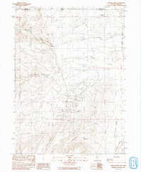
1991 Map of Cordero Mine
USGS Topo · Published 1991About this map
The Cordero Mine and Mc Dermitt Mine dominate this high-desert landscape on the border of Humboldt County, Nevada, and Malheur County, Oregon. In the early 1990s, the area's industrial character is defined by extensive mercury mining operations, marked by numerous prospect pits, mine dumps, and large tailing ponds north of McConnell Canyon. The map reveals the intricate network of mining infrastructure, including a substation and a major transmission line crossing the valley floor. Away from the industrial activity, the Quinn River Valley and McDermitt Creek provide water for cattle operations like the Washburn Ranch and Lucky Seven Ranch. The eastern edge of the sheet includes the boundary of the Fort Mc Dermitt Indian Reservation, highlighting the intersection of tribal lands, private ranching, and large-scale resource extraction in this corner of the Great Basin.
Find a feature on this map
29 named features on this map. Tap any name to fly to it.
Don’t see what you’re looking for? This feature index may not catch every label — zoom into the map to look around manually.
Map Details
Editions of this 1991 Cordero Mine Map
This is the sole edition of this map. No revisions or reprints were ever made.
Other maps of this area

1882 · Paradise
USGS Topo · 1:250,000

1893 · Paradise
USGS Topo · 1:250,000

1955 · McDermitt
USGS Topo · 1:250,000

1955 · Jordan Valley
USGS Topo · 1:250,000

1957 · Jordan Valley
USGS Topo · 1:250,000

1958 · Jordan Valley
USGS Topo · 1:250,000

1959 · McDermitt
USGS Topo · 1:250,000

1959 · McDermitt
USGS Topo · 1:62,500

1959 · Jordan Meadow
USGS Topo · 1:62,500
1982 · Tenmile Ranch
USGS Topo · 1:24,000