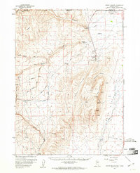
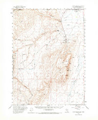
1959 Map of Jordan Meadow
USGS Topo · Published 1961About this map
McDermitt sits at the northern edge of this high-desert landscape where the Oregon and Nevada border meets. The economy of the late 1950s is etched into the terrain through the operations at the Cordero Mine and the nearby Cordero Sch, supporting a community of workers and their families. Ranching outposts like Lucky Seven Ranch and Washburn Ranch mark the persistent presence of agricultural life in the shadow of the Hoppin Peaks and Sallent Peak.
Find a feature on this map
49 named features on this map. Tap any name to fly to it.
Don’t see what you’re looking for? This feature index may not catch every label — zoom into the map to look around manually.
Map Details
Editions of this 1959 Jordan Meadow Map
2 editions found
Other maps of this area

1882 · Paradise
USGS Topo · 1:250,000

1886 · Disaster
USGS Topo · 1:250,000

1893 · Paradise
USGS Topo · 1:250,000

1893 · Disaster
USGS Topo · 1:250,000

1954 · Vya
USGS Topo · 1:250,000

1955 · McDermitt
USGS Topo · 1:250,000

1955 · Jordan Valley
USGS Topo · 1:250,000

1955 · Adel
USGS Topo · 1:250,000

1957 · Adel
USGS Topo · 1:250,000

1957 · Jordan Valley
USGS Topo · 1:250,000