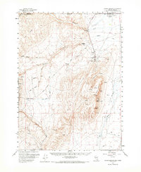
1959 Map of Jordan Meadow
USGS Topo · Published 1973About this map
The high desert landscape along the Nevada and Oregon border centers on the industrial and ranching activity of the late 1950s. The Cordero Mine and its accompanying Cordero Sch serve as a focal point of commerce and community in the northeastern portion of the quadrangle, situated just south of the Ft McDermitt Indian Res. The area is defined by a series of north-south running canyons and ridges, including the prominent Hoppin Peaks and Long Ridge, which separate the drainage of McDermitt Creek from the Quinn River valley.
Find a feature on this map
38 named features on this map. Tap any name to fly to it.
Don’t see what you’re looking for? This feature index may not catch every label — zoom into the map to look around manually.
Map Details
Editions of this 1959 Jordan Meadow Map
2 editions found

Other maps of this area

1882 · Paradise
USGS Topo · 1:250,000

1886 · Disaster
USGS Topo · 1:250,000

1893 · Paradise
USGS Topo · 1:250,000

1893 · Disaster
USGS Topo · 1:250,000

1954 · Vya
USGS Topo · 1:250,000

1955 · McDermitt
USGS Topo · 1:250,000

1955 · Jordan Valley
USGS Topo · 1:250,000

1955 · Adel
USGS Topo · 1:250,000

1957 · Adel
USGS Topo · 1:250,000

1957 · Jordan Valley
USGS Topo · 1:250,000