1970s Maps of Strawberry Hill, Caliente
Explore 2 historic maps of Strawberry Hill from the 1970s. These maps offer a rare glimpse into what life looked like during the 1970s — showing old roads, neighborhoods, homes, and landmarks that have changed or disappeared over time.
Whether you're researching your family's past, planning a metal detecting trip, or studying how Strawberry Hill's landscape evolved across the 1970s, these high-resolution maps are a powerful tool for exploring the history of this region.
- Focus on a specific era: All maps on this page are from the 1970s, giving you a focused view of this time period.
- See what’s changed: Compare century-old streets, trails, and buildings to today's modern landscape using overlays and satellite layers.
- Research with precision: Use these maps for genealogy, historical research, land use analysis, or educational projects.
- View, download, or print: Maps are fully viewable online in high resolution, and can be downloaded or printed for your own records.
Start exploring Strawberry Hill's history through authentic maps from the 1970s. This is your window into the past.
Strawberry Hill, Caliente maps
(2)- 1970 Map of Caliente, 1973 Print
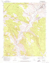 1970 Caliente1973 Print · USGSMeadow Valley and the Clover Mountains come into sharp focus in the 1970s as the railroad dictates the area's growth. Trace the rails through Caliente to the smaller settlement at Etna or locate the IOOF Cem and Pictographs.2 unique versions available
 - 1978 Map of Caliente, 1995 Print
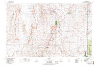 1978 Caliente1995 Print · USGSEastern Nevada in the late 1970s was a landscape of deep canyons and active mining operations. Researchers can trace the Union Pacific rail corridor through Caliente or locate early silver and lead sites like the Prince Mine Centennial Shaft.
End of results
Showing maps 1-2 of 2
Frequently asked questions
- What are the different types of historical maps available for Strawberry Hill?
- What is the oldest map of Strawberry Hill?
- Where can I purchase historical maps of Strawberry Hill for my home or office?
- Where can I download high-res historical maps of Strawberry Hill?
- Are there historical topographic maps available for Strawberry Hill?
- Is there historical aerial imagery available for Strawberry Hill?
- Where are historical maps of Strawberry Hill sourced from?