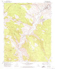
1970 Map of Caliente
USGS Topo · Published 1973About this map
Caliente serves as the focal point of this Nevada landscape, where the Union Pacific railroad line follows the narrow corridor of Meadow Valley. The town's infrastructure in the early 1970s is captured in detail, showing the County Hospital, IOOF Cem, and the Nevada Girls Training Center just north of the rail yards. The surrounding terrain is defined by dramatic elevation changes, moving from the canyon floors up into the Clover Mountains and toward Baldy Mountain. To the south, the valley narrows significantly at Etna, where the map identifies Pictographs on the canyon walls, providing a rare glimpse into the area's ancient history alongside more modern features like the Kershaw-Ryan State Park and its various springs.
Find a feature on this map
48 named features on this map. Tap any name to fly to it.
Don’t see what you’re looking for? This feature index may not catch every label — zoom into the map to look around manually.
Map Details
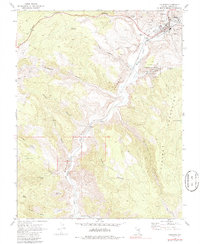
Editions of this 1970 Caliente Map
2 editions found
Other maps of this area

1885 · Pioche
USGS Topo · 1:250,000

1886 · Pioche
USGS Topo · 1:250,000

1954 · Caliente
USGS Topo · 1:250,000

1959 · Caliente
USGS Topo · 1:250,000

1969 · Elgin NE
USGS Topo · 1:24,000

1969 · Slidy Mountain
USGS Topo · 1:24,000
1970 · Caliente NW
USGS Topo · 1:24,000
1970 · Chokecherry Mtn.
USGS Topo · 1:24,000
1970 · Chief Mountain
USGS Topo · 1:24,000
1972 · Indian Cove
USGS Topo · 1:24,000