1900s (20th Century) Maps of Panaca, Nevada
Explore 5 historic maps of Panaca from the 1900s (20th Century). These maps offer a rare glimpse into what life looked like during the 1900s — showing old roads, neighborhoods, homes, and landmarks that have changed or disappeared over time.
Whether you're researching your family's past, planning a metal detecting trip, or studying how Panaca's landscape evolved across the 1900s, these high-resolution maps are a powerful tool for exploring the history of this region.
- Focus on a specific era: All maps on this page are from the 1900s, giving you a focused view of this time period.
- See what’s changed: Compare century-old streets, trails, and buildings to today's modern landscape using overlays and satellite layers.
- Research with precision: Use these maps for genealogy, historical research, land use analysis, or educational projects.
- View, download, or print: Maps are fully viewable online in high resolution, and can be downloaded or printed for your own records.
Start exploring Panaca's history through authentic maps from the 1900s. This is your window into the past.
Panaca, NV maps
(5)- 1921 Map of NW 1/4 Panaca
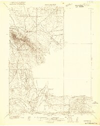 1921 NW 1/4 Panaca1921 Print · USGSLincoln County mining and desert ranching are preserved here during the peak of the silver-lead era. Genealogists and historians can trace the paths of the Pacific (Narrow Gauge) railroad and locate family landmarks like Newman Ranch and Bullionville.2 unique versions available
 - 1954 Map of Caliente
 1954 Caliente1954 Print · USGSLincoln County at mid-century reveals a landscape defined by the Union Pacific rail line and expanding Cold War military ranges. Researchers can trace the heritage of mining towns like Pioche, locate the Prince Mine, or find early airfields at Panaca Airport and Caliente.5 unique versions available
 - 1959 Map of Caliente
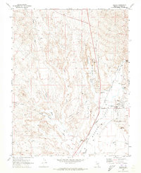
 1959 Caliente1959 Print · USGSSoutheast Nevada in the late fifties was a landscape of deep mines and sprawling military reservations. Genealogists and historians can trace the Union Pacific rail line through Caliente or locate operations like the Bristol Silver Mine and Groom Mine.2 unique versions available
 - 1970 Map of Panaca, 1973 Print
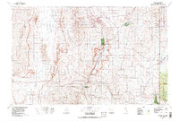
 1970 Panaca1973 Print · USGSPanaca and the Meadow Valley Wash appear here in the early seventies, showcasing a landscape of civic centers and geologic wonders. Researchers can trace the Bullionville (Site), locate the Bullionville Cem, and explore the formations of Cathedral Gorge State Park.
 - 1978 Map of Caliente, 1995 Print
 1978 Caliente1995 Print · USGSEastern Nevada in the late 1970s was a landscape of deep canyons and active mining operations. Researchers can trace the Union Pacific rail corridor through Caliente or locate early silver and lead sites like the Prince Mine Centennial Shaft.
End of results
Showing maps 1-5 of 5
Top cities near Panaca
- Caliente historical maps
- Pioche historical maps
- Bennett Springs historical maps
- Ursine historical maps
- Dry Valley historical maps
- Beaverdam historical maps
Frequently asked questions
- What are the different types of historical maps available for Panaca?
- What is the oldest map of Panaca?
- Where can I purchase historical maps of Panaca for my home or office?
- Where can I download high-res historical maps of Panaca?
- Are there historical topographic maps available for Panaca?
- Is there historical aerial imagery available for Panaca?
- Where are historical maps of Panaca sourced from?