1900s (20th Century) Maps of Virginia City, Nevada
Explore 10 historic maps of Virginia City from the 1900s (20th Century). These maps offer a rare glimpse into what life looked like during the 1900s — showing old roads, neighborhoods, homes, and landmarks that have changed or disappeared over time.
Whether you're researching your family's past, planning a metal detecting trip, or studying how Virginia City's landscape evolved across the 1900s, these high-resolution maps are a powerful tool for exploring the history of this region.
- Focus on a specific era: All maps on this page are from the 1900s, giving you a focused view of this time period.
- See what’s changed: Compare century-old streets, trails, and buildings to today's modern landscape using overlays and satellite layers.
- Research with precision: Use these maps for genealogy, historical research, land use analysis, or educational projects.
- View, download, or print: Maps are fully viewable online in high resolution, and can be downloaded or printed for your own records.
Start exploring Virginia City's history through authentic maps from the 1900s. This is your window into the past.
Virginia City, NV maps
(10)- 1950 Map of Virginia City, 1955 Print
 1950 Virginia City1955 Print · USGSVirginia City and the Comstock mining corridor are seen here at mid-century, amidst a dense concentration of historic shafts and early settlement sites. Researchers can trace the legacy of silver mining through Gold Hill, the Utah Shaft, and several cemeteries that overlook the mountain ranges.3 unique versions available
 - 1952 Map of Virginia City
 1952 Virginia City1952 Print · USGSStorey County's mining heartland is revealed in the mid-century, documenting the legendary Comstock Lode settlements and engineering works. Researchers can trace the massive Sutro Tunnel, locate the Lousetown (Site), and find family roots in Gold Hill or Virginia City.2 unique versions available
 - 1957 Map of Reno, 1963 Print
 1957 Reno1963 Print · USGSWestern Nevada in the early sixties is a land of sprawling desert sinks and rising mountain ranges. Genealogists and historians can trace the rail-and-river network connecting Reno, the mining legacy of Rawhide Mine, and the boundaries of the Pyramid Lake Indian Reservation.5 unique versions available
 - 1959 Map of Reno
 1959 Reno1959 Print · USGSWestern Nevada in the late fifties was a land of expanding military airbases and high-desert irrigation projects. You can trace the lineage of the Comstock era through Carson City, locate the Pony Express Monument, or study the rail networks of the Southern Pacific RR.
 - 1960 Map of Reno
 1960 Reno1960 Print · USGSThe high desert of western Nevada comes alive in this mid-century survey of the Reno-Tahoe region. Genealogists and historians can trace rail lines like the Southern Pacific RR and locate remote outposts such as Olinghouse, Nixon, and the Olinghouse Mine.2 unique versions available
 - 1960 Map of Virginia City, 1976 Print
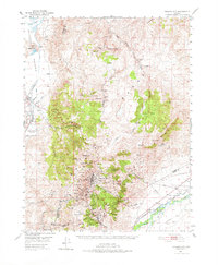 1960 Virginia City1976 Print · USGSThe Comstock Lode is shown in detail at mid-century, mapping the industrial footprint of the silver mining boom. Genealogists and historians can locate mining infrastructure, the Sutro Tunnel, and settlements like Gold Hill, Silver City, and American Flat.
 - 1967 Map of Virginia City, 1971 Print
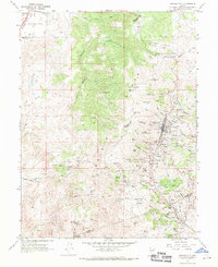 1967 Virginia City1971 Print · USGSVirginia City and the Comstock Lode mining district are shown here in the late sixties, highlighting the intense industrial footprint of the Nevada silver boom. Local historians can trace the foundations of Gold Hill, the Sutro Tunnel, and family sites near the Hebrew Cem.3 unique versions available
 - 1974 Map of Virginia City, 1977 Print
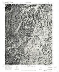 1974 Virginia City1977 Print · USGSVirginia City and the Comstock region are seen from above in the mid-1970s, revealing the dense settlement patterns and the mining-scarred landscape. Trace historic drainages like Gold Canyon or examine the rugged layout of the Virginia Range.
 - 1979 Map of Carson City, 1980 Print
 1979 Carson City1980 Print · USGSWestern Nevada in the late seventies reveals a landscape of historic mining districts and expanding mountain communities. Researchers can trace the Comstock Lode through Virginia City, locate the Stewart Indian School, or explore the shores of Lake Tahoe near Incline Village.2 unique versions available
 - 1994 Map of Virginia City
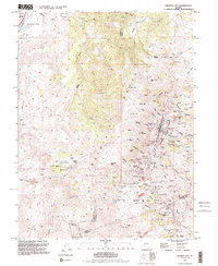 1994 Virginia City1994 Print · USGSThe Comstock Lode district is preserved in this late-century survey, detailing the mining heart of Nevada. Genealogists and historians can trace the foundations of Virginia City through landmarks like the 4th Ward Sch Museum and numerous historic plots including the Masonic Cem.2 unique versions available
End of results
Showing maps 1-10 of 10
Top cities near Virginia City
- Reno historical maps
- Sparks historical maps
- Carson City historical maps
- Dayton historical maps
- Indian Hills historical maps
- New Washoe City historical maps
See more
Frequently asked questions
- What are the different types of historical maps available for Virginia City?
- What is the oldest map of Virginia City?
- Where can I purchase historical maps of Virginia City for my home or office?
- Where can I download high-res historical maps of Virginia City?
- Are there historical topographic maps available for Virginia City?
- Is there historical aerial imagery available for Virginia City?
- Where are historical maps of Virginia City sourced from?