1980s Maps of Nixon, Nevada
Explore 2 historic maps of Nixon from the 1980s. These maps offer a rare glimpse into what life looked like during the 1980s — showing old roads, neighborhoods, homes, and landmarks that have changed or disappeared over time.
Whether you're researching your family's past, planning a metal detecting trip, or studying how Nixon's landscape evolved across the 1980s, these high-resolution maps are a powerful tool for exploring the history of this region.
- Focus on a specific era: All maps on this page are from the 1980s, giving you a focused view of this time period.
- See what’s changed: Compare century-old streets, trails, and buildings to today's modern landscape using overlays and satellite layers.
- Research with precision: Use these maps for genealogy, historical research, land use analysis, or educational projects.
- View, download, or print: Maps are fully viewable online in high resolution, and can be downloaded or printed for your own records.
Start exploring Nixon's history through authentic maps from the 1980s. This is your window into the past.
Nixon, NV maps
(2)- 1980 Map of Reno
 1980 Reno1980 Print · USGSReno and its high-desert surroundings appear in transition during the 1980s, balancing rapid urban expansion with its deep mining and ranching roots. Genealogists and historians can trace the Southern Pacific line through Fernley or locate local landmarks like Mountain View Cem and the Ruth Mine.3 unique versions available
 - 1986 Map of Nixon
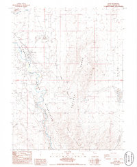 1986 Nixon1986 Print · USGSIn the mid-1980s, the community of Nixon sat at the crossroads of the desert and the Truckee River within the Pyramid Lake Indian Reservation. Researchers can trace the Old Railroad Grade, locate Graves, and identify water infrastructure like Numana Dam.
End of results
Showing maps 1-2 of 2
Top cities near Nixon
Frequently asked questions
- What are the different types of historical maps available for Nixon?
- What is the oldest map of Nixon?
- Where can I purchase historical maps of Nixon for my home or office?
- Where can I download high-res historical maps of Nixon?
- Are there historical topographic maps available for Nixon?
- Is there historical aerial imagery available for Nixon?
- Where are historical maps of Nixon sourced from?