1990s Maps of Prospect Village, Reno
Explore 2 historic maps of Prospect Village from the 1990s. These maps offer a rare glimpse into what life looked like during the 1990s — showing old roads, neighborhoods, homes, and landmarks that have changed or disappeared over time.
Whether you're researching your family's past, planning a metal detecting trip, or studying how Prospect Village's landscape evolved across the 1990s, these high-resolution maps are a powerful tool for exploring the history of this region.
- Focus on a specific era: All maps on this page are from the 1990s, giving you a focused view of this time period.
- See what’s changed: Compare century-old streets, trails, and buildings to today's modern landscape using overlays and satellite layers.
- Research with precision: Use these maps for genealogy, historical research, land use analysis, or educational projects.
- View, download, or print: Maps are fully viewable online in high resolution, and can be downloaded or printed for your own records.
Start exploring Prospect Village's history through authentic maps from the 1990s. This is your window into the past.
Prospect Village, Reno maps
(2)- 1994 Map of Steamboat
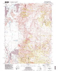 1994 Steamboat1994 Print · USGSThe Reno city limits met the rugged Virginia Range during the mid-nineties, capturing a landscape of geothermal power and old mining sites. Researchers can locate the Washington Site, the thermal Hot Wells, and the Castle Peak Mine.2 unique versions available
 - 1994 Map of Mount Rose NE
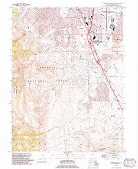 1994 Mount Rose NE1994 Print · USGSSouthern Reno meets the high Sierra Nevada foothills in the 1990s as suburban development pushes toward the wilderness. Trace the growth of Truckee Meadows neighborhoods near Meadowood Mall and locate landmarks like Virginia Lake and the Wheeler Ranch Prospect.2 unique versions available
End of results
Showing maps 1-2 of 2
Frequently asked questions
- What are the different types of historical maps available for Prospect Village?
- What is the oldest map of Prospect Village?
- Where can I purchase historical maps of Prospect Village for my home or office?
- Where can I download high-res historical maps of Prospect Village?
- Are there historical topographic maps available for Prospect Village?
- Is there historical aerial imagery available for Prospect Village?
- Where are historical maps of Prospect Village sourced from?