1980s Maps of Clarksville, New Hampshire
Explore 8 historic maps of Clarksville from the 1980s. These maps offer a rare glimpse into what life looked like during the 1980s — showing old roads, neighborhoods, homes, and landmarks that have changed or disappeared over time.
Whether you're researching your family's past, planning a metal detecting trip, or studying how Clarksville's landscape evolved across the 1980s, these high-resolution maps are a powerful tool for exploring the history of this region.
- Focus on a specific era: All maps on this page are from the 1980s, giving you a focused view of this time period.
- See what’s changed: Compare century-old streets, trails, and buildings to today's modern landscape using overlays and satellite layers.
- Research with precision: Use these maps for genealogy, historical research, land use analysis, or educational projects.
- View, download, or print: Maps are fully viewable online in high resolution, and can be downloaded or printed for your own records.
Start exploring Clarksville's history through authentic maps from the 1980s. This is your window into the past.
Clarksville, NH maps
(8)- 1986 Map of Groveton
 1986 Groveton1986 Print · USGSThe North Country's rugged borderlands come into focus in the mid-1980s, tracing the river-and-rail corridors of the Connecticut River valley. Genealogists and historians can locate family landmarks in North Stratford, Groveton, and Guildhall or trace the Canadian National RR.2 unique versions available
 - 1986 Map of Sherbrooke
 1986 Sherbrooke1986 Print · USGSThe Great North Woods of the mid-eighties appear in detail across this survey of the New Hampshire and Canadian borderlands. Researchers can trace the entire chain of the First Connecticut Lake through the fourth, alongside remote settlements like Pittsburg and Beecher Falls.2 unique versions available
 - 1989 Map of Mount Pisgah
 1989 Mount Pisgah1989 Print · USGSNorthern New Hampshire's high timberlands and historic school land grants are meticulously detailed in this late-century survey. You can trace the remote drainage of the Dead Diamond River and locate the isolated Swift Diamond Farm near the foot of Crystal Mountain.2 unique versions available
 - 1989 Map of Pittsburg
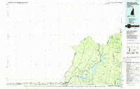
 1989 Pittsburg1989 Print · USGSNorthern New Hampshire's river-border country is captured here during the late eighties, showing the headwaters of the Connecticut River. Researchers can trace the varied terrain of Tabor Notch, the infrastructure of Lake Francis, and remote settlements like Pittsburg and Clarksville.3 unique versions available
 - 1989 Map of Diamond Pond
 1989 Diamond Pond1989 Print · USGSCoos County’s high timberlands and headwaters are captured here in the late eighties, showing a landscape shaped by forestry and northern recreation. Researchers can trace remote camps and early settlements like Felton Camp, Upper Kidderville, and Old Ramsay Camp among the peaks of Tumble Dick Mountain.2 unique versions available
 - 1989 Map of Magalloway Mtn
 1989 Magalloway Mtn1989 Print · USGSCoos County, New Hampshire, is captured here in the late eighties, showing a wilderness of timber grants and high summits. You can trace the remote outposts at Camp Otter and Camp No 9 or follow the waters from Beaver Pond to the Dead Diamond River.
 - 1989 Map of Lake Francis
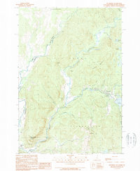
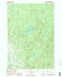
 1989 Lake Francis1989 Print · USGSUpper Coos County in the late 1980s reveals a landscape transitioning between timber management and forest recreation. Trace the sites of local landmarks like the Covered Bridge, the Cem at Happy Corner, and the expansive Lake Francis.
 - 1989 Map of Lovering Mountain
 1989 Lovering Mountain1989 Print · USGSThe northern reaches of the Connecticut River valley are captured here in the late eighties as they cross from New Hampshire into Vermont. Researchers can trace local landmarks like Beaver Brook Falls, the Mohawk River, and the settlement of Stewartstown Hollow.2 unique versions available
End of results
Showing maps 1-8 of 8
Top cities near Clarksville
- Colebrook historical maps
- Stewartstown historical maps
- Pittsburg historical maps
- Stratford historical maps
- Columbia historical maps
- Canaan historical maps
See more
Frequently asked questions
- What are the different types of historical maps available for Clarksville?
- What is the oldest map of Clarksville?
- Where can I purchase historical maps of Clarksville for my home or office?
- Where can I download high-res historical maps of Clarksville?
- Are there historical topographic maps available for Clarksville?
- Is there historical aerial imagery available for Clarksville?
- Where are historical maps of Clarksville sourced from?