1930s Maps of Jefferson, New Hampshire
Explore 4 historic maps of Jefferson from the 1930s. These maps offer a rare glimpse into what life looked like during the 1930s — showing old roads, neighborhoods, homes, and landmarks that have changed or disappeared over time.
Whether you're researching your family's past, planning a metal detecting trip, or studying how Jefferson's landscape evolved across the 1930s, these high-resolution maps are a powerful tool for exploring the history of this region.
- Focus on a specific era: All maps on this page are from the 1930s, giving you a focused view of this time period.
- See what’s changed: Compare century-old streets, trails, and buildings to today's modern landscape using overlays and satellite layers.
- Research with precision: Use these maps for genealogy, historical research, land use analysis, or educational projects.
- View, download, or print: Maps are fully viewable online in high resolution, and can be downloaded or printed for your own records.
Start exploring Jefferson's history through authentic maps from the 1930s. This is your window into the past.
Jefferson, NH maps
(4)- 1935 Map of Whitefield
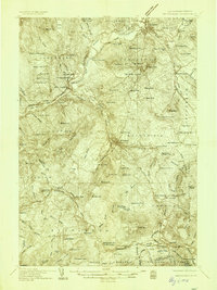 1935 Whitefield1935 Print · USGSThe White Mountains region in the mid-1930s shows a landscape of busy rail junctions and early aviation fields. Trace old family plots at Baptist Hill Cem or locate vanished structures near Mill Village and Quebec Junction.4 unique versions available
 - 1935 Map of Mt. Washington
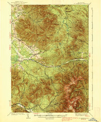
 1935 Mt. Washington1935 Print · USGSCoos County at the height of the Great Depression shows a landscape where mountain rail tourism and rugged hiking trails intersect. Trace the path of the Mount Washington Cog Railway or locate old valley sites like Ravine House and the Gore Sch.4 unique versions available
 - 1938 Map of Mt. Washington
 1938 Mt. Washington1938 Print · USGSThe White Mountains in the late 1930s reveal a landscape of mountain resorts and rugged timber camps. Trace the Mount Washington Cog RR, find the Gore Sch, or explore early trail networks like the Crawford Path and Gulfside Trail.4 unique versions available
 - 1938 Map of Whitefield
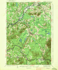 1938 Whitefield1938 Print · USGSCoos County at the end of the Great Depression was a landscape of mountain rail junctions and valley farms. Trace the vanished railroad stops at Quebec Junction, locate family homesteads near Baptist Hill Sch, or find the CCC Camp at Pierce Bridge.3 unique versions available
End of results
Showing maps 1-4 of 4
Top cities near Jefferson
- Berlin historical maps
- Lancaster historical maps
- Gorham historical maps
- Whitefield historical maps
- Northumberland historical maps
- Milan historical maps
See more
Top neighborhoods of Jefferson
- Highlands historical maps
- Riverton historical maps
- Baileys historical maps
- Jefferson Highland historical maps
- Starr King historical maps
- Waumbeck Junction historical maps
Frequently asked questions
- What are the different types of historical maps available for Jefferson?
- What is the oldest map of Jefferson?
- Where can I purchase historical maps of Jefferson for my home or office?
- Where can I download high-res historical maps of Jefferson?
- Are there historical topographic maps available for Jefferson?
- Is there historical aerial imagery available for Jefferson?
- Where are historical maps of Jefferson sourced from?