1980s Maps of Jefferson, New Hampshire
Explore 6 historic maps of Jefferson from the 1980s. These maps offer a rare glimpse into what life looked like during the 1980s — showing old roads, neighborhoods, homes, and landmarks that have changed or disappeared over time.
Whether you're researching your family's past, planning a metal detecting trip, or studying how Jefferson's landscape evolved across the 1980s, these high-resolution maps are a powerful tool for exploring the history of this region.
- Focus on a specific era: All maps on this page are from the 1980s, giving you a focused view of this time period.
- See what’s changed: Compare century-old streets, trails, and buildings to today's modern landscape using overlays and satellite layers.
- Research with precision: Use these maps for genealogy, historical research, land use analysis, or educational projects.
- View, download, or print: Maps are fully viewable online in high resolution, and can be downloaded or printed for your own records.
Start exploring Jefferson's history through authentic maps from the 1980s. This is your window into the past.
Jefferson, NH maps
(6)- 1982 Map of Pliny Range, 1983 Print
 1982 Pliny Range1983 Print · USGSCoos County, New Hampshire, is captured in the early 1980s as a high-altitude landscape of small mountain villages and expansive forest. Genealogists and hikers can trace old family sites near Jefferson Highland or locate the Forest Vale Cem and St Johns Ch.
 - 1982 Map of Lancaster, 1983 Print
 1982 Lancaster1983 Print · USGSThe Connecticut River valley comes alive in the early eighties as a network of rail lines and riverside towns. Genealogists and historians can trace family-named hills and find local landmarks like St Matthews Ch, the Covered Bridge, and Riverside Cem.2 unique versions available
 - 1982 Map of Bethlehem, 1983 Print
 1982 Bethlehem1983 Print · USGSUpper Grafton and Coos County are shown in the early eighties as the mountain rail corridors still shaped local life. Genealogists and hikers can trace old family burial sites like Burns Cem, follow the Boston and Maine Railroad, or locate the Twin Mountain Fish Hatchery.
 - 1982 Map of Mt. Washington, 1983 Print
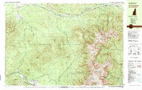 1982 Mt. Washington1983 Print · USGSThe Presidential Range and its iconic summit are captured here in the early eighties, showing the region as a mature hub for mountain tourism and transit. Trace the historic paths of the Mount Washington Cog Railway, explore the high-altitude Lakes of the Clouds, and locate the Lady of the Mountain Ch at Bretton Woods.2 unique versions available
 - 1986 Map of Mount Washington
 1986 Mount Washington1986 Print · USGSThe northern New England highlands are shown here in the mid-eighties, centered on the high peaks and river valleys of the New Hampshire borderlands. Researchers can trace historic transportation lines like the Mount Washington Cog Railway and the Maine Central Railroad near Gorham and Lancaster.
 - 1988 Map of Mount Washington, 1989 Print
 1988 Mount Washington1989 Print · USGSThe New Hampshire high country in the late 1980s is defined by its iconic peaks and the legacy of mountain tourism. Trace the routes of the historic Mount Washington Cog Railway and the Maine Central RR through the gaps of Crawford Notch State Park.
End of results
Showing maps 1-6 of 6
Top cities near Jefferson
- Berlin historical maps
- Lancaster historical maps
- Gorham historical maps
- Whitefield historical maps
- Northumberland historical maps
- Milan historical maps
See more
Top neighborhoods of Jefferson
- Highlands historical maps
- Riverton historical maps
- Baileys historical maps
- Jefferson Highland historical maps
- Starr King historical maps
- Waumbeck Junction historical maps
Frequently asked questions
- What are the different types of historical maps available for Jefferson?
- What is the oldest map of Jefferson?
- Where can I purchase historical maps of Jefferson for my home or office?
- Where can I download high-res historical maps of Jefferson?
- Are there historical topographic maps available for Jefferson?
- Is there historical aerial imagery available for Jefferson?
- Where are historical maps of Jefferson sourced from?