1980s Maps of Stratford, New Hampshire
Explore 7 historic maps of Stratford from the 1980s. These maps offer a rare glimpse into what life looked like during the 1980s — showing old roads, neighborhoods, homes, and landmarks that have changed or disappeared over time.
Whether you're researching your family's past, planning a metal detecting trip, or studying how Stratford's landscape evolved across the 1980s, these high-resolution maps are a powerful tool for exploring the history of this region.
- Focus on a specific era: All maps on this page are from the 1980s, giving you a focused view of this time period.
- See what’s changed: Compare century-old streets, trails, and buildings to today's modern landscape using overlays and satellite layers.
- Research with precision: Use these maps for genealogy, historical research, land use analysis, or educational projects.
- View, download, or print: Maps are fully viewable online in high resolution, and can be downloaded or printed for your own records.
Start exploring Stratford's history through authentic maps from the 1980s. This is your window into the past.
Stratford, NH maps
(7)- 1986 Map of Groveton
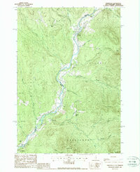
 1986 Groveton1986 Print · USGSThe North Country's rugged borderlands come into focus in the mid-1980s, tracing the river-and-rail corridors of the Connecticut River valley. Genealogists and historians can locate family landmarks in North Stratford, Groveton, and Guildhall or trace the Canadian National RR.2 unique versions available
 - 1988 Map of Bloomfield
 1988 Bloomfield1988 Print · USGSThe upper Connecticut River Valley comes into focus in the late eighties, showing the quiet border between Vermont and New Hampshire. Genealogists and hikers can trace the geography around Bloomfield, from the Yellow Bogs to the summits of Potash Mtn and French Mtn.
 - 1988 Map of Stratford
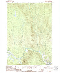
 1988 Stratford1988 Print · USGSThe upper Connecticut River valley comes to life in the late eighties, capturing the border communities of North Stratford and Maidstone in high detail. Genealogists and historians can trace family-named sites like Masons, old transport routes including the Old RR Grade, and remote water bodies like Stratford Bog Pond.
 - 1988 Map of Tinkerville
 1988 Tinkerville1988 Print · USGSThe Upper Connecticut River valley at the New Hampshire-Vermont border reveals its late-twentieth-century rural character here. Researchers can trace the riverfront settlements of Lemington and Tinkerville or locate landmarks like the Columbia Bridge and Wallace Pond.3 unique versions available
 - 1988 Map of Maidstone Lake
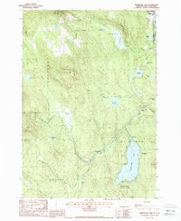 1988 Maidstone Lake1988 Print · USGSThe Northeast Kingdom's transition from timber industry to recreation is visible in this late-century survey of the Connecticut River valley. Trace the legacy of old industrial sites like Browns Mill and the Walker Dam (Site) near Maidstone Lake.
 - 1988 Map of Blue Mountain
 1988 Blue Mountain1988 Print · USGSThe high country of Coos County is revealed in the late eighties, showing a landscape shaped by narrow passes and steep peaks. Researchers can trace the drainage of Simms Stream or locate remote landmarks like Bungy and Cranberry Bog Pond.
 - 1988 Map of Percy Peaks
 1988 Percy Peaks1988 Print · USGSCoos County's high country is captured here in the late eighties, showing a landscape defined by timber and drainage. Researchers can trace the course of the Upper Ammonoosuc River and find family-named landmarks like Jimmy Cole Ledge and Potters Ledge.2 unique versions available
End of results
Showing maps 1-7 of 7
Top cities near Stratford
- Berlin historical maps
- Lancaster historical maps
- Northumberland historical maps
- Colebrook historical maps
- Milan historical maps
- Lunenburg historical maps
See more
Top neighborhoods of Stratford
- Mapleton historical maps
- North Stratford historical maps
- Masons historical maps
- Beatties historical maps
Frequently asked questions
- What are the different types of historical maps available for Stratford?
- What is the oldest map of Stratford?
- Where can I purchase historical maps of Stratford for my home or office?
- Where can I download high-res historical maps of Stratford?
- Are there historical topographic maps available for Stratford?
- Is there historical aerial imagery available for Stratford?
- Where are historical maps of Stratford sourced from?