1950s Maps of Strafford County, New Hampshire
Explore 16 historic maps of Strafford County from the 1950s. These maps offer a rare glimpse into what life looked like during the 1950s — showing old roads, neighborhoods, homes, and landmarks that have changed or disappeared over time.
Whether you're researching your family's past, planning a metal detecting trip, or studying how Strafford County's landscape evolved across the 1950s, these high-resolution maps are a powerful tool for exploring the history of this region.
- Focus on a specific era: All maps on this page are from the 1950s, giving you a focused view of this time period.
- See what’s changed: Compare century-old streets, trails, and buildings to today's modern landscape using overlays and satellite layers.
- Research with precision: Use these maps for genealogy, historical research, land use analysis, or educational projects.
- View, download, or print: Maps are fully viewable online in high resolution, and can be downloaded or printed for your own records.
Start exploring Strafford County's history through authentic maps from the 1950s. This is your window into the past.
Strafford County, NH maps
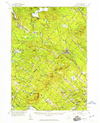
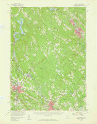
(16)- 1950 Map of Dover East
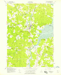
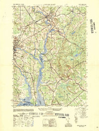 1950 Dover East1950 Print · USGSThe borderlands of New Hampshire and Maine are captured here at mid-century, following the winding Salmon Falls River through a landscape of rail-connected towns. Researchers can trace historic cemeteries and schools such as Pine Hill Cem, Pear Yard School, and the junction at Eliot Depot.
 - 1952 Map of Dover West
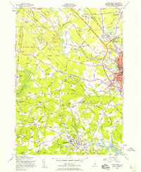
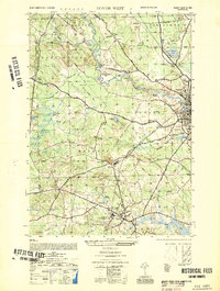 1952 Dover West1952 Print · USGSCoastal New Hampshire's interior during the early 1950s shows a landscape of small townships and rail-connected farms before major highway expansion. Researchers can trace the mid-century footprint of the University of New Hampshire, local landmarks like the Madbury Church, and the route of the Maine Central RR.
 - 1952 Map of Portsmouth
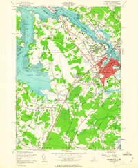
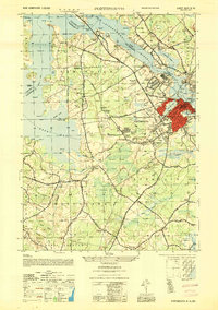 1952 Portsmouth1952 Print · USGSCoastal New Hampshire and Maine are shown in detail during the early fifties, centering on the harbor and the bustling city of Portsmouth. Trace the development of the Piscataqua River waterfront, find ancestral sites like Winnicut Mills, and locate old rail hubs at Greenland Station or Newington Station.
 - 1956 Map of Dover East, 1958 Print
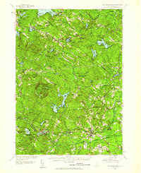
 1956 Dover East1958 Print · USGSThe Maine and New Hampshire borderlands are captured here in the mid-fifties, showing the industrial riverfronts and rail junctions of the Piscataqua basin. Researchers can locate family landmarks like Berwick Academy, Pine Hill Cemetery, and the Rollinsford Station during the early days of the turnpike expansion.5 unique versions available
 - 1956 Map of Newmarket, 1958 Print
 1956 Newmarket1958 Print · USGSCoastal New Hampshire's river-fed mill towns and rail junctions are caught in detail during the mid-1950s. Genealogists and historians can trace family plots at Riverside Cem or locate the vital rail hub at Rockingham Junction and the small settlement of Littlefield.5 unique versions available
 - 1956 Map of Dover West, 1958 Print
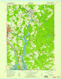
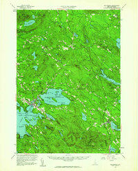
 1956 Dover West1958 Print · USGSThe townships of Durham, Madbury, and Barrington are captured in the mid-1950s as the Spaulding Turnpike was still under construction. Genealogists can trace family plots like Layne Cem and Torr Cem, or locate the historic Green Hill Chapel and the early layout of the University of New Hampshire.9 unique versions available
 - 1956 Map of Dover, 1960 Print
 1956 Dover1960 Print · USGSCoastal New Hampshire and the Maine borderlands are captured here during a period of massive transition as modern infrastructure meets historic mill towns. Researchers can trace the development of Pease Air Force Base or locate family roots at Winnicut Mills and Packers Falls Cem.4 unique versions available
 - 1956 Map of Portland, 1963 Print
 1956 Portland1963 Print · USGSSouthern Maine and eastern New Hampshire are captured here in the mid-fifties, during a time of major highway expansion and military growth. You can trace the path of the Maine Turnpike and locate landmarks like the Portsmouth Naval Shipyard and Sebago Lake.4 unique versions available
 - 1956 Map of Portsmouth, 1963 Print
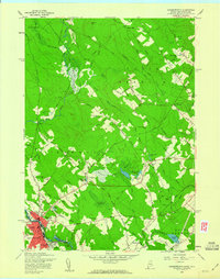
 1956 Portsmouth1963 Print · USGSCoastal New Hampshire and Maine are shown here during the mid-fifties, just as the massive Pease Air Force Base was established. Researchers can trace family sites from Winnicut Mills to Atlantic Heights and find local landmarks like Breakfast Hill.4 unique versions available
 - 1957 Map of Mt. Pawtuckaway, 1959 Print
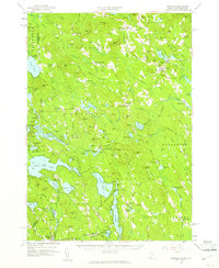
 1957 Mt. Pawtuckaway1959 Print · USGSRockingham and Strafford counties are shown in the late fifties, featuring a network of traditional villages and expanding recreational lakes. Researchers can trace historic sites like Nottingham Square, Deerfield Parade, and the Watson Academy.4 unique versions available
 - 1957 Map of Alton, 1959 Print
 1957 Alton1959 Print · USGSEastern New Hampshire’s Lakes Region and the Blue Hill Range are captured here during the late 1950s. Genealogists and researchers can locate old schoolhouses and crossroads, including Austin Cate Academy, Gerrish Chapel, and the Nute Ridge Sch.4 unique versions available
 - 1958 Map of Wolfeboro, 1960 Print
 1958 Wolfeboro1960 Print · USGSCentral New Hampshire's lake country is captured here in the late fifties, showing the established rail lines and summer colonies. Genealogists can trace family names across Federal Corner, locate Union Church, or study the grounds of Brewster Academy.2 unique versions available
 - 1958 Map of Somersworth, 1960 Print
 1958 Somersworth1960 Print · USGSSomersworth and Berwick thrive along the state line in the late fifties, showcasing a landscape of river-powered industry and rural homesteads. Genealogists can trace family footprints at Oak Woods Ch, Holy Trinity Sch, and numerous hilltop cemeteries near Beech Ridge.4 unique versions available
 - 1958 Map of Newfield, 1961 Print
 1958 Newfield1961 Print · USGSThe Maine-New Hampshire borderlands in the late fifties show a landscape of interconnected glacial lakes and upland settlements. Genealogists and historians can trace family-named sites like Stevens Corner, the Shapleigh Mem Sch Cem, and industrial relics at Limerick Mills.5 unique versions available
 - 1958 Map of Berwick, 1961 Print
 1958 Berwick1961 Print · USGSMid-century York County and Strafford County come to life as the post-war era transforms the river towns of the Maine-New Hampshire border. Researchers can trace the sprawling rail lines of the Boston and Maine Railroad or locate local landmarks like Nasson College, Milton Mills, and St Ignatius Ch.3 unique versions available
 - 1959 Map of Portland
 1959 Portland1959 Print · USGSThe Maine and New Hampshire coastlines meet in this mid-century portrait of maritime commerce and inland rail networks. Researchers can trace the legacy of coastal defense at Fort Williams and follow the historic path of the Maine Central RR through the White Mountain National Forest.2 unique versions available
End of results
Showing maps 1-16 of 16
Top cities of Strafford County
- Dover historical maps
- Rochester historical maps
- Somersworth historical maps
- Durham historical maps
- Barrington historical maps
- Farmington historical maps
See more
Frequently asked questions
- What are the different types of historical maps available for Strafford County?
- What is the oldest map of Strafford County?
- Where can I purchase historical maps of Strafford County for my home or office?
- Where can I download high-res historical maps of Strafford County?
- Are there historical topographic maps available for Strafford County?
- Is there historical aerial imagery available for Strafford County?
- Where are historical maps of Strafford County sourced from?