1980s Maps of Strafford County, New Hampshire
Explore 17 historic maps of Strafford County from the 1980s. These maps offer a rare glimpse into what life looked like during the 1980s — showing old roads, neighborhoods, homes, and landmarks that have changed or disappeared over time.
Whether you're researching your family's past, planning a metal detecting trip, or studying how Strafford County's landscape evolved across the 1980s, these high-resolution maps are a powerful tool for exploring the history of this region.
- Focus on a specific era: All maps on this page are from the 1980s, giving you a focused view of this time period.
- See what’s changed: Compare century-old streets, trails, and buildings to today's modern landscape using overlays and satellite layers.
- Research with precision: Use these maps for genealogy, historical research, land use analysis, or educational projects.
- View, download, or print: Maps are fully viewable online in high resolution, and can be downloaded or printed for your own records.
Start exploring Strafford County's history through authentic maps from the 1980s. This is your window into the past.
Strafford County, NH maps
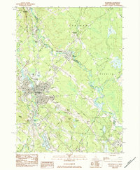
(17)- 1981 Map of Northwood
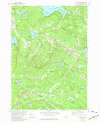 1981 Northwood1981 Print · USGSSoutheastern New Hampshire’s lake country is captured here in the early eighties, showcasing the historic village clusters of Northwood and Deerfield. Genealogists and historians can trace family landmarks like Bartlett Cem, find the old White Sch, or locate the radio tower on Saddleback Mountain.3 unique versions available
 - 1981 Map of Epping
 1981 Epping1981 Print · USGSIn the early 1980s, the Rockingham County countryside remained a patchwork of small villages, historic river systems, and rail corridors. Researchers can trace ancestral plots and early civic life through Nottingham Square, the Ladd Cem, and the old Boston and Maine Railroad lines.
 - 1981 Map of Barrington
 1981 Barrington1981 Print · USGSSoutheastern New Hampshire’s lake country is captured here in the early eighties, showing a landscape of wooded hills and interconnected waterways. Genealogists and local historians can trace family plots at Pine Grove Cem, find the Canaan Chapel, or locate old landmarks like Mount Misery.2 unique versions available
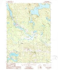
 - 1983 Map of Great East Lake, 1984 Print
 1983 Great East Lake1984 Print · USGSThe Maine and New Hampshire border region is captured here in the early 1980s, showcasing a landscape of interconnected glacial lakes and rural settlements. Researchers can trace local heritage through landmarks like Milton Mills, the Maple Grove Church, and McCutcheon Corners.2 unique versions available
 - 1983 Map of Milton, 1984 Print
 1983 Milton1984 Print · USGSThe interstate border along the Salmon Falls River comes to life in the early 1980s, showing the tight connection between riverside industry and rural crossroads. Local researchers can trace the Boston and Maine rail line, find the Nute High Sch, and locate old cemeteries like Forest Grove Cem.2 unique versions available
 - 1983 Map of Rochester, 1984 Print
 1983 Rochester1984 Print · USGSRochester and the Maine-New Hampshire borderlands are captured here in the early eighties as the region balanced its industrial roots with suburban growth. Researchers can trace family sites like Forest Glade Cem or locate old transit points such as N Rochester (Hayes Sta) and Pickering.2 unique versions available
 - 1985 Map of Kittery, 1986 Print
 1985 Kittery1986 Print · USGSThe Maine and New Hampshire borderlands are shown here in the mid-eighties, centered on the strategic Piscataqua River harbor. Genealogists and historians can trace the development of coastal towns like York or locate the sprawling Portsmouth Naval Shipyard and Pease Air Force Base.2 unique versions available
 - 1985 Map of Portland, 1986 Print
 1985 Portland1986 Print · USGSThe Maine coast and Sebago Lake region are captured in the mid-1980s, showcasing the transition from traditional maritime centers to a modern transportation hub. Genealogists and historians can trace rail lines like the Grand Trunk RR and find local landmarks such as the U.S. Marine Hospital or Old Orchard Beach.2 unique versions available
 - 1986 Map of Lake Winnipesaukee
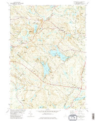
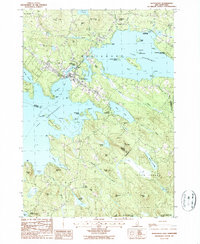
 1986 Lake Winnipesaukee1986 Print · USGSThe Lakes Region in the mid-eighties shows a landscape of dense water bodies and mountain ranges at the peak of its twentieth-century character. Trace the legacy of old rail lines like the Boston and Maine RR and locate historic centers from Rumney Depot to Melvin Village.2 unique versions available
 - 1986 Map of Concord
 1986 Concord1986 Print · USGSCentral New Hampshire in the mid-eighties shows a landscape of river-valley cities and rural villages connected by the growing interstate system. Genealogists and historians can trace old community centers like Gilmanton Ironworks or follow the Boston and Maine Railroad through Concord and Tilton.
 - 1987 Map of Alton
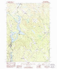
 1987 Alton1987 Print · USGSThe southeastern shore of Lake Winnipesaukee comes alive in the late eighties, showing the transition from lakeside recreation to permanent residential growth. Genealogists can trace family lines through Stockbridge Corners and New Durham Corner, while local historians can locate the Fish Hatchery and Alton Bay State Forest.2 unique versions available
 - 1987 Map of Farmington
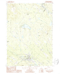 1987 Farmington1987 Print · USGSThe town of Farmington and the surrounding ridges of Strafford County are captured here in the late 1980s. Genealogists and local historians can trace family-named sites from Middleton Corners to Hayes Corner, or follow the Old Railroad Grade along the Cocheco River.
 - 1987 Map of Sanbornville
 1987 Sanbornville1987 Print · USGSSanbornville and the surrounding lake country are captured in the late eighties, documenting a landscape where rail history still marks the local geography. Researchers can trace rural cemetery locations and old rail stops like Burleyville Station and Cotton Valley Station.
 - 1987 Map of Baxter Lake
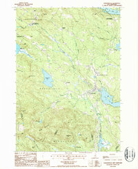
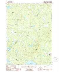
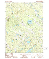 1987 Baxter Lake1987 Print · USGSSoutheastern New Hampshire in the late eighties is a landscape of high ridges and quiet crossroads settlements. Genealogists and hikers can trace old routes through Center Strafford, locate family landmarks like Meaderboro Corner, or explore Blue Job Mtn State Forest.2 unique versions available
 - 1987 Map of Parker Mountain
 1987 Parker Mountain1987 Print · USGSThe rural hills of Strafford and Barnstead are captured here in the late twentieth century, showing a landscape defined by traditional family-named crossroads. Researchers can locate historic burial sites at several mapped cemeteries or trace the geography of old homesteads near Lockes Corner, Shackford Corners, and the shores of Bow Lake.2 unique versions available
 - 1987 Map of Wolfeboro
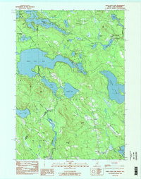
 1987 Wolfeboro1987 Print · USGSThe Lakes Region of New Hampshire thrives in the late eighties, centered on the bustling resort community of Wolfeboro. Genealogists and historians can trace family-named landmarks like Cates Hill and Hayes Hill, or explore the shorelines of Lake Winnipesaukee and Lake Wentworth.
 - 1988 Map of Concord
 1988 Concord1988 Print · USGSCentral New Hampshire in the late eighties centers on the industrial and political hub of Concord. Researchers can trace the Boston and Maine RR along the Merrimack River or locate recreation landmarks like Bear Brook State Park and Massabesic Lake.
End of results
Showing maps 1-17 of 17
Top cities of Strafford County
- Dover historical maps
- Rochester historical maps
- Somersworth historical maps
- Durham historical maps
- Barrington historical maps
- Farmington historical maps
See more
Frequently asked questions
- What are the different types of historical maps available for Strafford County?
- What is the oldest map of Strafford County?
- Where can I purchase historical maps of Strafford County for my home or office?
- Where can I download high-res historical maps of Strafford County?
- Are there historical topographic maps available for Strafford County?
- Is there historical aerial imagery available for Strafford County?
- Where are historical maps of Strafford County sourced from?