1990s Maps of Strafford County, New Hampshire
Explore 5 historic maps of Strafford County from the 1990s. These maps offer a rare glimpse into what life looked like during the 1990s — showing old roads, neighborhoods, homes, and landmarks that have changed or disappeared over time.
Whether you're researching your family's past, planning a metal detecting trip, or studying how Strafford County's landscape evolved across the 1990s, these high-resolution maps are a powerful tool for exploring the history of this region.
- Focus on a specific era: All maps on this page are from the 1990s, giving you a focused view of this time period.
- See what’s changed: Compare century-old streets, trails, and buildings to today's modern landscape using overlays and satellite layers.
- Research with precision: Use these maps for genealogy, historical research, land use analysis, or educational projects.
- View, download, or print: Maps are fully viewable online in high resolution, and can be downloaded or printed for your own records.
Start exploring Strafford County's history through authentic maps from the 1990s. This is your window into the past.
Strafford County, NH maps
(5)- 1995 Map of Great East Lake, 1999 Print
 1995 Great East Lake1999 Print · USGSThe Maine and New Hampshire borderlands are captured here in the mid-nineties, showing a landscape of interconnected lakes and small mill towns. Local historians can trace family-named sites like McCutcheon Corners, rural landmarks like Maple Grove Ch, and the course of the Salmon Falls River.
 - 1995 Map of Epping, 1999 Print
 1995 Epping1999 Print · USGSRockingham County at the close of the twentieth century remains a landscape of historic river villages and rural cemeteries. Genealogists can trace family names at Plumer Cem and Sleeper Cem, or explore old centers like Nottingham Square and Wadley Falls.
 - 1995 Map of Barrington, 1999 Print
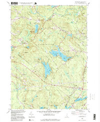 1995 Barrington1999 Print · USGSBarrington and its surrounding hamlets are shown in the mid-nineties as the region balanced its rural character with growing university and recreational footprints. Genealogists and local researchers can trace historic property markers and burial grounds like Pine Grove Cem or locate the UNH Recreation Area at Mendums Pond.
 - 1995 Map of Northwood, 2000 Print
 1995 Northwood2000 Print · USGSNorthwood and Deerfield are shown here in the mid-nineties, a landscape of glacial lakes and historic village hamlets at the border of Rockingham and Strafford counties. Genealogists can locate family landmarks like Bartlett Cem and Stevens Cem, while local historians can trace the early layout of Northwood Narrows and Deerfield Parade.
 - 1998 Map of Somersworth, 1999 Print
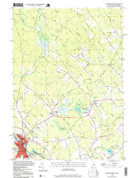 1998 Somersworth1999 Print · USGSSomersworth and Berwick straddle the Maine-New Hampshire state line in the late twentieth century, showing a landscape shaped by the Little River and local industry. Researchers can locate family landmarks like Evergreen Cem, Oak Woods Ch, and the site of Mathews Millpond.
End of results
Showing maps 1-5 of 5
Top cities of Strafford County
- Dover historical maps
- Rochester historical maps
- Somersworth historical maps
- Durham historical maps
- Barrington historical maps
- Farmington historical maps
See more
Frequently asked questions
- What are the different types of historical maps available for Strafford County?
- What is the oldest map of Strafford County?
- Where can I purchase historical maps of Strafford County for my home or office?
- Where can I download high-res historical maps of Strafford County?
- Are there historical topographic maps available for Strafford County?
- Is there historical aerial imagery available for Strafford County?
- Where are historical maps of Strafford County sourced from?