1950s Maps of Barrington, New Hampshire
Explore 8 historic maps of Barrington from the 1950s. These maps offer a rare glimpse into what life looked like during the 1950s — showing old roads, neighborhoods, homes, and landmarks that have changed or disappeared over time.
Whether you're researching your family's past, planning a metal detecting trip, or studying how Barrington's landscape evolved across the 1950s, these high-resolution maps are a powerful tool for exploring the history of this region.
- Focus on a specific era: All maps on this page are from the 1950s, giving you a focused view of this time period.
- See what’s changed: Compare century-old streets, trails, and buildings to today's modern landscape using overlays and satellite layers.
- Research with precision: Use these maps for genealogy, historical research, land use analysis, or educational projects.
- View, download, or print: Maps are fully viewable online in high resolution, and can be downloaded or printed for your own records.
Start exploring Barrington's history through authentic maps from the 1950s. This is your window into the past.
Barrington, NH maps
(8)- 1952 Map of Dover West
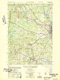 1952 Dover West1952 Print · USGSCoastal New Hampshire's interior during the early 1950s shows a landscape of small townships and rail-connected farms before major highway expansion. Researchers can trace the mid-century footprint of the University of New Hampshire, local landmarks like the Madbury Church, and the route of the Maine Central RR.
 - 1956 Map of Dover West, 1958 Print
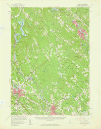
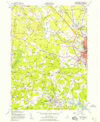 1956 Dover West1958 Print · USGSThe townships of Durham, Madbury, and Barrington are captured in the mid-1950s as the Spaulding Turnpike was still under construction. Genealogists can trace family plots like Layne Cem and Torr Cem, or locate the historic Green Hill Chapel and the early layout of the University of New Hampshire.9 unique versions available
 - 1956 Map of Dover, 1960 Print
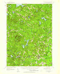
 1956 Dover1960 Print · USGSCoastal New Hampshire and the Maine borderlands are captured here during a period of massive transition as modern infrastructure meets historic mill towns. Researchers can trace the development of Pease Air Force Base or locate family roots at Winnicut Mills and Packers Falls Cem.4 unique versions available
 - 1956 Map of Portland, 1963 Print
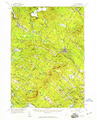
 1956 Portland1963 Print · USGSSouthern Maine and eastern New Hampshire are captured here in the mid-fifties, during a time of major highway expansion and military growth. You can trace the path of the Maine Turnpike and locate landmarks like the Portsmouth Naval Shipyard and Sebago Lake.4 unique versions available
 - 1957 Map of Mt. Pawtuckaway, 1959 Print
 1957 Mt. Pawtuckaway1959 Print · USGSRockingham and Strafford counties are shown in the late fifties, featuring a network of traditional villages and expanding recreational lakes. Researchers can trace historic sites like Nottingham Square, Deerfield Parade, and the Watson Academy.4 unique versions available
 - 1957 Map of Alton, 1959 Print
 1957 Alton1959 Print · USGSEastern New Hampshire’s Lakes Region and the Blue Hill Range are captured here during the late 1950s. Genealogists and researchers can locate old schoolhouses and crossroads, including Austin Cate Academy, Gerrish Chapel, and the Nute Ridge Sch.4 unique versions available
 - 1958 Map of Berwick, 1961 Print
 1958 Berwick1961 Print · USGSMid-century York County and Strafford County come to life as the post-war era transforms the river towns of the Maine-New Hampshire border. Researchers can trace the sprawling rail lines of the Boston and Maine Railroad or locate local landmarks like Nasson College, Milton Mills, and St Ignatius Ch.3 unique versions available
 - 1959 Map of Portland
 1959 Portland1959 Print · USGSThe Maine and New Hampshire coastlines meet in this mid-century portrait of maritime commerce and inland rail networks. Researchers can trace the legacy of coastal defense at Fort Williams and follow the historic path of the Maine Central RR through the White Mountain National Forest.2 unique versions available
End of results
Showing maps 1-8 of 8
Top cities near Barrington
- Dover historical maps
- Rochester historical maps
- Sanford historical maps
- Portsmouth historical maps
- Somersworth historical maps
- Durham historical maps
See more
Top neighborhoods of Barrington
Frequently asked questions
- What are the different types of historical maps available for Barrington?
- What is the oldest map of Barrington?
- Where can I purchase historical maps of Barrington for my home or office?
- Where can I download high-res historical maps of Barrington?
- Are there historical topographic maps available for Barrington?
- Is there historical aerial imagery available for Barrington?
- Where are historical maps of Barrington sourced from?