1940s Maps of Old Tappan, New Jersey
Explore 12 historic maps of Old Tappan from the 1940s. These maps offer a rare glimpse into what life looked like during the 1940s — showing old roads, neighborhoods, homes, and landmarks that have changed or disappeared over time.
Whether you're researching your family's past, planning a metal detecting trip, or studying how Old Tappan's landscape evolved across the 1940s, these high-resolution maps are a powerful tool for exploring the history of this region.
- Focus on a specific era: All maps on this page are from the 1940s, giving you a focused view of this time period.
- See what’s changed: Compare century-old streets, trails, and buildings to today's modern landscape using overlays and satellite layers.
- Research with precision: Use these maps for genealogy, historical research, land use analysis, or educational projects.
- View, download, or print: Maps are fully viewable online in high resolution, and can be downloaded or printed for your own records.
Start exploring Old Tappan's history through authentic maps from the 1940s. This is your window into the past.
Old Tappan, NJ maps
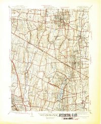
(12)- 1940 Map of Hackensack
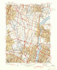 1940 Hackensack1940 Print · USGSBergen County suburban life comes into focus just before the mid-century boom, showing the transition from towns to dense residential grids. Genealogists can trace family plots at Riverside Cemetery or locate early schools like Steuben Sch and Willard Sch.3 unique versions available
 - 1940 Map of Nyack, 1952 Print
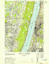
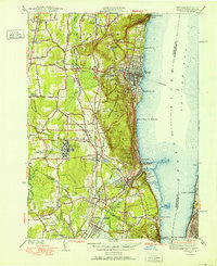 1940 Nyack1952 Print · USGSThe Hudson River shoreline and Rockland County interior are captured here just before mid-century suburban expansion. Researchers can trace the extensive grounds of the Rockland State Hospital, the paths of the West Shore RR, and historic sites like Sneden Landing.
 - 1942 Map of Nyack
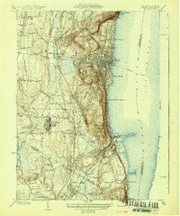 1942 Nyack1942 Print · USGSThe Hudson River riverfront and the high ridges of the Palisades define this area in the early years of the war. Researchers can trace the legacy of rail and river travel through the Tarrytown Ferry and the Erie RR, or locate family sites near Sneden Landing and Rockland State Hospital.
 - 1942 Map of Passaic
 1942 Passaic1942 Print · USGSNorthern New Jersey and New York harbor appear in detail at the start of the war, showing a landscape of burgeoning suburbs and vital industry. Trace family roots and local history across the Passaic River valley, from Paterson to the Watchung Mountains.
 - 1943 Map of Nyack
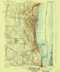 1943 Nyack1943 Print · USGSSoutheastern Rockland County and the Bergen County border are shown in the early 1940s as riverfront villages and rail-dependent towns. Trace the sprawling grounds of the Rockland State Hospital or locate ancestors in Oak Hill Cemetery and Rockland Cemetery.2 unique versions available
 - 1944 Map of Newark, 1971 Print
 1944 Newark1971 Print · USGSThe industrial corridor from Philadelphia to New York was in a period of massive transition during the mid-forties. Genealogists and researchers can trace the rail lines of the Lehigh Valley RR, locate military installations like Picatinny Arsenal, and explore the early sprawl near Levittown.5 unique versions available
 - 1945 Map of Park Ridge
 1945 Park Ridge1945 Print · USGSThe New York and New Jersey borderlands at the end of the war show a maturing landscape of suburban towns and industrial centers. Researchers can trace local heritage through landmarks like Lederle Laboratories, St Anthonys Cem, and the Erie railroad stops.2 unique versions available
 - 1947 Map of Yonkers
 1947 Yonkers1947 Print · USGSThe Hudson River waterfronts of New York and New Jersey are captured here in the late forties, showing a landscape of suburban growth and industrial strength. Trace the old rail lines of the West Shore RR and find historic sites like the Spreckel Estate and N Y Colored Orphan Asylum.2 unique versions available
 - 1947 Map of Hartford, 1955 Print
 1947 Hartford1955 Print · USGSSouthern New England and the Hudson Valley are shown in detail during the post-war expansion era. Genealogists and researchers can trace local landmarks from the State Capitol and Yale University to the Stratford Lighthouse and Woodlawn Cem.2 unique versions available
 - 1948 Map of Hartford
 1948 Hartford1948 Print · USGSSouthern New England is captured here in the late 1940s, showcasing a landscape of thriving industrial cities and developing parkways. Genealogists and historians can trace the rail networks of the New York New Haven and Hartford RR or locate coastal defense sites like Fort Terry and Camp Shanks.2 unique versions available
 - 1949 Map of Newark
 1949 Newark1949 Print · USGSThe industrial corridor between Philadelphia and New York comes alive in this post-war survey. Genealogists and historians can trace the massive rail networks of the Reading Railroad and locate major installations like Fort Dix or Picatinny Arsenal.2 unique versions available
 - 1949 Map of New York, 1951 Print
 1949 New York1951 Print · USGSLong Island and its surrounding waters are documented here in the late 1940s, just as the postwar suburban boom began to transform the region. Genealogists and historians can trace the early layouts of Idlewild Airport, Mitchell Field, and the established routes of the Long Island RR.
End of results
Showing maps 1-12 of 12
Top cities near Old Tappan
- New York historical maps
- North Hempstead historical maps
- Yonkers historical maps
- Ramapo historical maps
- Paterson historical maps
- Greenburgh historical maps
See more
Frequently asked questions
- What are the different types of historical maps available for Old Tappan?
- What is the oldest map of Old Tappan?
- Where can I purchase historical maps of Old Tappan for my home or office?
- Where can I download high-res historical maps of Old Tappan?
- Are there historical topographic maps available for Old Tappan?
- Is there historical aerial imagery available for Old Tappan?
- Where are historical maps of Old Tappan sourced from?