1950s Maps of Union, New Jersey
Explore 8 historic maps of Union from the 1950s. These maps offer a rare glimpse into what life looked like during the 1950s — showing old roads, neighborhoods, homes, and landmarks that have changed or disappeared over time.
Whether you're researching your family's past, planning a metal detecting trip, or studying how Union's landscape evolved across the 1950s, these high-resolution maps are a powerful tool for exploring the history of this region.
- Focus on a specific era: All maps on this page are from the 1950s, giving you a focused view of this time period.
- See what’s changed: Compare century-old streets, trails, and buildings to today's modern landscape using overlays and satellite layers.
- Research with precision: Use these maps for genealogy, historical research, land use analysis, or educational projects.
- View, download, or print: Maps are fully viewable online in high resolution, and can be downloaded or printed for your own records.
Start exploring Union's history through authentic maps from the 1950s. This is your window into the past.
Union, NJ maps
(8)- 1952 Map of Cakepoulin Creek
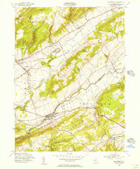
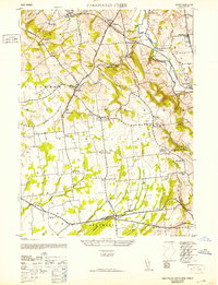 1952 Cakepoulin Creek1952 Print · USGSHunterdon County during the early fifties shows a landscape of small farming hamlets and active rail corridors. Genealogists can trace family roots through landmarks like the Mt Salem Cemetery, Oakgrove Grange Hall, and Jutland School.2 unique versions available
 - 1953 Map of Frenchtown
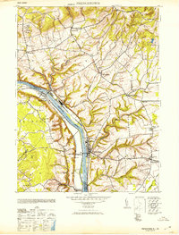 1953 Frenchtown1953 Print · USGSThe Delaware River valley thrived mid-century with active rail lines and riverside industry connecting New Jersey and Pennsylvania communities. Genealogists can trace family roots through several rural schoolhouses and landmarks like Alexandria Cemetery, Lodge Hall, and Milford.
 - 1954 Map of High Bridge, 1957 Print
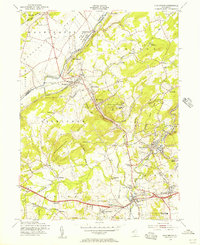 1954 High Bridge1957 Print · USGSMid-century Hunterdon County is captured here as a landscape of industrial river towns and sprawling state institutions. Genealogists and local historians can trace family plots at Evergreen Cem or locate the old Stone Mill near the waters of Lake Solitude.5 unique versions available
 - 1955 Map of Pittstown, 1956 Print
 1955 Pittstown1956 Print · USGSHunterdon County is shown in the mid-1950s as a patchwork of productive townships and historic crossroad settlements. Researchers can trace the lineage of local landmarks like Bethlehem Cem, the Lehigh Valley rail line, and vanished tavern sites like Point Tavern.6 unique versions available
 - 1955 Map of Frenchtown, 1956 Print
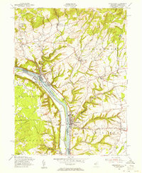 1955 Frenchtown1956 Print · USGSThe Delaware River valley thrived as a corridor for rail and commerce in the mid-1950s, bridging New Jersey and Pennsylvania communities. Researchers can trace family roots through riverside settlements like Frenchtown and Milford, or locate rural landmarks such as Milford Union Ch and Alexandria Cem.5 unique versions available
 - 1955 Map of Bloomsbury, 1956 Print
 1955 Bloomsbury1956 Print · USGSThe Musconetcong Valley in the mid-1950s reveals a landscape where historic industrial infrastructure meets post-war growth. Genealogists and historians can trace family-named roads and rural hamlets like Stewartsville, Asbury, and the path of the old Morris Canal.4 unique versions available
 - 1956 Map of Newark
 1956 Newark1956 Print · USGSThe industrial heart of the Mid-Atlantic is captured here at the dawn of the highway era, tracing the dense corridors between Newark and Philadelphia. Genealogists and local historians can map the rail networks of the Reading RR or locate mid-century military life at Fort Dix Military Reservation.2 unique versions available
 - 1957 Map of Newark
 1957 Newark1957 Print · USGSThe industrial and military heart of the Mid-Atlantic is mapped during its post-war suburban boom. Genealogists and historians can trace the intricate rail corridors of the Reading Railroad and locate key landmarks from Princeton University to Fort Hancock.
End of results
Showing maps 1-8 of 8
Top cities near Union
- Hillsborough Township historical maps
- Mount Olive historical maps
- Easton historical maps
- Raritan Township historical maps
- Hopewell Township historical maps
- Readington Township historical maps
See more
Top neighborhoods of Union
- Hensfoot historical maps
- Norton historical maps
- Perryville historical maps
- Pattenburg historical maps
- Mount Salem historical maps
- Van Syckel historical maps
See more
Frequently asked questions
- What are the different types of historical maps available for Union?
- What is the oldest map of Union?
- Where can I purchase historical maps of Union for my home or office?
- Where can I download high-res historical maps of Union?
- Are there historical topographic maps available for Union?
- Is there historical aerial imagery available for Union?
- Where are historical maps of Union sourced from?