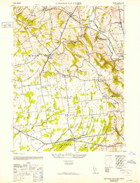
1952 Map of Cakepoulin Creek
USGS Topo · Published 1952About this map
The South Branch Raritan River and its numerous tributaries, including Cakepoulin Creek and Wickecheoke Creek, define the rolling landscape of central Hunterdon County. This mid-century survey captures a region where agriculture and small-town infrastructure remain closely linked to the rail lines. The Lehigh Valley railroad cuts through the northern townships, serving communities like Jutland, Lansdowne, and Pittstown. Local civic life is anchored by landmarks such as the Oakgrove Grange Hall, Lodge Hall, and various rural schoolhouses like Independence School and Summit School.
Find a feature on this map
50 named features on this map. Tap any name to fly to it.
Don’t see what you’re looking for? This feature index may not catch every label — zoom into the map to look around manually.
Map Details
Editions of this 1952 Cakepoulin Creek Map
2 editions found
Other maps of this area

1890 · Easton
USGS Topo · 1:62,500

1890 · High Bridge
USGS Topo · 1:62,500

1890 · Lambertville
USGS Topo · 1:62,500

1890 · Doylestown
USGS Topo · 1:62,500

1891 · Easton
USGS Topo · 1:62,500

1891 · Lambertville
USGS Topo · 1:62,500

1891 · Doylestown
USGS Topo · 1:62,500

1894 · Lambertville
USGS Topo · 1:62,500

1898 · High Bridge
USGS Topo · 1:62,500

1900 · Raritan
USGS Topo · 1:125,000