1950s Maps of West Amwell Township, New Jersey
Explore 6 historic maps of West Amwell Township from the 1950s. These maps offer a rare glimpse into what life looked like during the 1950s — showing old roads, neighborhoods, homes, and landmarks that have changed or disappeared over time.
Whether you're researching your family's past, planning a metal detecting trip, or studying how West Amwell Township's landscape evolved across the 1950s, these high-resolution maps are a powerful tool for exploring the history of this region.
- Focus on a specific era: All maps on this page are from the 1950s, giving you a focused view of this time period.
- See what’s changed: Compare century-old streets, trails, and buildings to today's modern landscape using overlays and satellite layers.
- Research with precision: Use these maps for genealogy, historical research, land use analysis, or educational projects.
- View, download, or print: Maps are fully viewable online in high resolution, and can be downloaded or printed for your own records.
Start exploring West Amwell Township's history through authentic maps from the 1950s. This is your window into the past.
West Amwell Township, NJ maps
(6)- 1953 Map of Lambertville, 1955 Print
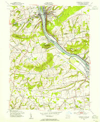 1953 Lambertville1955 Print · USGSThe Delaware River corridor comes to life in the mid-1950s, showing the historic river towns of Lambertville and New Hope at a time of steady regional growth. Genealogists and historians can trace the foundations of local life through rural landmarks like St Martins Ch, Fairfield Sch, and the grounds of Washington Crossing State Park.7 unique versions available
 - 1954 Map of Hopewell, 1955 Print
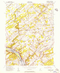
 1954 Hopewell1955 Print · USGSMid-century New Jersey rural life is frozen in time here, showing the transition from established towns to the rolling farm country of the Delaware Valley hinterlands. Genealogists can trace family names through landmarks like Larisons Corners, Snydertown, and the Childrens Home near the Reading Railroad.4 unique versions available
 - 1954 Map of Stockton, 1956 Print
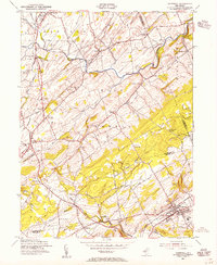
 1954 Stockton1956 Print · USGSHunterdon County and the Delaware River valley are captured in the mid-1950s, revealing a landscape of historic river towns and rural crossroads. Genealogists can locate family landmarks like Barber Cem, the Green Sergeant Covered Bridge, and the West Amwell Sch.6 unique versions available
 - 1954 Map of Pennington, 1956 Print
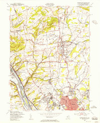 1954 Pennington1956 Print · USGSMid-century Mercer County was a landscape of expanding educational institutions and quiet crossroads hamlets. Genealogists and historians can trace the growth of Ewing and Pennington, as well as landmarks like Bear Tavern, St Hedwigs Cem, and the Reading railroad line.6 unique versions available
 - 1956 Map of Newark
 1956 Newark1956 Print · USGSThe industrial heart of the Mid-Atlantic is captured here at the dawn of the highway era, tracing the dense corridors between Newark and Philadelphia. Genealogists and local historians can map the rail networks of the Reading RR or locate mid-century military life at Fort Dix Military Reservation.2 unique versions available
 - 1957 Map of Newark
 1957 Newark1957 Print · USGSThe industrial and military heart of the Mid-Atlantic is mapped during its post-war suburban boom. Genealogists and historians can trace the intricate rail corridors of the Reading Railroad and locate key landmarks from Princeton University to Fort Hancock.
End of results
Showing maps 1-6 of 6
Top cities near West Amwell Township
- Hamilton Township historical maps
- Trenton historical maps
- Middletown Township historical maps
- Bridgewater Township historical maps
- Hillsborough Township historical maps
- Ewing Township historical maps
See more
Top neighborhoods of West Amwell Township
Frequently asked questions
- What are the different types of historical maps available for West Amwell Township?
- What is the oldest map of West Amwell Township?
- Where can I purchase historical maps of West Amwell Township for my home or office?
- Where can I download high-res historical maps of West Amwell Township?
- Are there historical topographic maps available for West Amwell Township?
- Is there historical aerial imagery available for West Amwell Township?
- Where are historical maps of West Amwell Township sourced from?