1950s Maps of Hamilton Township, New Jersey
Explore 7 historic maps of Hamilton Township from the 1950s. These maps offer a rare glimpse into what life looked like during the 1950s — showing old roads, neighborhoods, homes, and landmarks that have changed or disappeared over time.
Whether you're researching your family's past, planning a metal detecting trip, or studying how Hamilton Township's landscape evolved across the 1950s, these high-resolution maps are a powerful tool for exploring the history of this region.
- Focus on a specific era: All maps on this page are from the 1950s, giving you a focused view of this time period.
- See what’s changed: Compare century-old streets, trails, and buildings to today's modern landscape using overlays and satellite layers.
- Research with precision: Use these maps for genealogy, historical research, land use analysis, or educational projects.
- View, download, or print: Maps are fully viewable online in high resolution, and can be downloaded or printed for your own records.
Start exploring Hamilton Township's history through authentic maps from the 1950s. This is your window into the past.
Hamilton Township, NJ maps
(7)- 1952 Map of Princeton
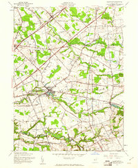
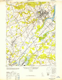 1952 Princeton1952 Print · USGSMid-century Central New Jersey shows a landscape shaped by academic institutions and the early growth of suburban hamlets. Genealogists and historians can trace Princeton University and the Lawrenceville School, or locate vanished industries like Maddocks Pottery Co.
 - 1954 Map of Princeton, 1956 Print
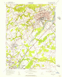 1954 Princeton1956 Print · USGSMid-century Princeton and Lawrenceville are captured here during a period of prestigious academic growth and steady infrastructure development. Genealogists and researchers can locate family-named landmarks and institutions like the Theological Seminary, Stony Brook Ch, and the Lawrenceville Cem.4 unique versions available
 - 1955 Map of Trenton West, 1957 Print
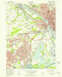 1955 Trenton West1957 Print · USGSThe Delaware Valley transformed during the mid-fifties as planned communities like Levittown and Fairless Hills rose beside the river. Researchers can trace early suburban development through family-centric neighborhoods like Oaktree Hollow and landmarks like Rider College or the 3 M Airport.5 unique versions available
 - 1956 Map of Newark
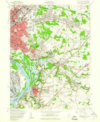
 1956 Newark1956 Print · USGSThe industrial heart of the Mid-Atlantic is captured here at the dawn of the highway era, tracing the dense corridors between Newark and Philadelphia. Genealogists and local historians can map the rail networks of the Reading RR or locate mid-century military life at Fort Dix Military Reservation.2 unique versions available
 - 1957 Map of Newark
 1957 Newark1957 Print · USGSThe industrial and military heart of the Mid-Atlantic is mapped during its post-war suburban boom. Genealogists and historians can trace the intricate rail corridors of the Reading Railroad and locate key landmarks from Princeton University to Fort Hancock.
 - 1957 Map of Trenton East, 1960 Print
 1957 Trenton East1960 Print · USGSMid-century development spreads eastward from the Delaware River during the late fifties as residential neighborhoods begin to fill the spaces between historic hamlets. Researchers can trace the era's institutional landscape at the State Reformatory, the State Fairgrounds, and local landmarks like St Anthonys Convent.6 unique versions available
 - 1957 Map of Allentown, 1961 Print
 1957 Allentown1961 Print · USGSAllentown and its surrounding townships appear at a mid-century crossroads where quiet millponds meet the emerging New Jersey Turnpike. Researchers can trace family history through sites like St Johns Ch, Windsor Cem, and the milling hamlets of Walnford and Kirbys Mills.3 unique versions available
End of results
Showing maps 1-7 of 7
Top cities near Hamilton Township
- Trenton historical maps
- Franklin Township historical maps
- Jackson Township historical maps
- Levittown historical maps
- Monroe Township historical maps
- East Brunswick Township historical maps
See more
Top neighborhoods of Hamilton Township
- Nottingham historical maps
- The Orchards historical maps
- Edgebrook historical maps
- Golden Crest historical maps
- Warner Village historical maps
- Haines Corner historical maps
See more
Frequently asked questions
- What are the different types of historical maps available for Hamilton Township?
- What is the oldest map of Hamilton Township?
- Where can I purchase historical maps of Hamilton Township for my home or office?
- Where can I download high-res historical maps of Hamilton Township?
- Are there historical topographic maps available for Hamilton Township?
- Is there historical aerial imagery available for Hamilton Township?
- Where are historical maps of Hamilton Township sourced from?