1940s Maps of Washington Township, New Jersey
Explore 7 historic maps of Washington Township from the 1940s. These maps offer a rare glimpse into what life looked like during the 1940s — showing old roads, neighborhoods, homes, and landmarks that have changed or disappeared over time.
Whether you're researching your family's past, planning a metal detecting trip, or studying how Washington Township's landscape evolved across the 1940s, these high-resolution maps are a powerful tool for exploring the history of this region.
- Focus on a specific era: All maps on this page are from the 1940s, giving you a focused view of this time period.
- See what’s changed: Compare century-old streets, trails, and buildings to today's modern landscape using overlays and satellite layers.
- Research with precision: Use these maps for genealogy, historical research, land use analysis, or educational projects.
- View, download, or print: Maps are fully viewable online in high resolution, and can be downloaded or printed for your own records.
Start exploring Washington Township's history through authentic maps from the 1940s. This is your window into the past.
Washington Township, NJ maps
(7)- 1943 Map of Hackettstown
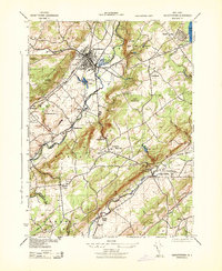 1943 Hackettstown1943 Print · USGSNew Jersey's northwestern hills and valleys come alive in this wartime survey, showing the industry and landscapes of the Musconetcong and Raritan watersheds. Genealogists and historians can trace rail lines to the N J Hosiery Mill, the State Fish Hatchery, and rural centers like Drakestown and Springtown.
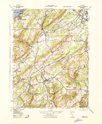
 - 1943 Map of Gladstone
 1943 Gladstone1943 Print · USGSSomerset and Morris counties are captured here during the early 1940s, showing a landscape of deep-rooted mining history and river-valley farming. Genealogists can locate family landmarks like St Bernards School, the DL & W RR corridor, and the sites of the Wortman Mine and Bartles Mine.
 - 1943 Map of Washington
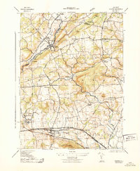
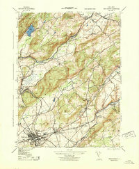 1943 Washington1943 Print · USGSWarren County at the height of the second World War reveals a busy landscape of industry and rail. Genealogists can trace family names at the Pequest Union Cemetery or find historic workplaces like Oxford Furnace and the Magnetite Mine.
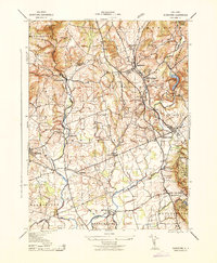
 - 1943 Map of Chester
 1943 Chester1943 Print · USGSMorris County was a landscape of rail-connected hamlets and river valleys during the early years of the war. Researchers can trace historic local life through sites like Hacklebarney State Park, the Flanders School, and the junction of the High Bridge Branch.
 - 1943 Map of Califon
 1943 Califon1943 Print · USGSHunterdon County during the early 1940s maintains its agrarian character along the winding South Branch Raritan River. Genealogists and historians can trace the foundations of local life at New Germantown, the Burrill Mine, and the N. J. State Reformatory.
 - 1944 Map of Newark, 1971 Print
 1944 Newark1971 Print · USGSThe industrial corridor from Philadelphia to New York was in a period of massive transition during the mid-forties. Genealogists and researchers can trace the rail lines of the Lehigh Valley RR, locate military installations like Picatinny Arsenal, and explore the early sprawl near Levittown.5 unique versions available
 - 1949 Map of Newark
 1949 Newark1949 Print · USGSThe industrial corridor between Philadelphia and New York comes alive in this post-war survey. Genealogists and historians can trace the massive rail networks of the Reading Railroad and locate major installations like Fort Dix or Picatinny Arsenal.2 unique versions available
End of results
Showing maps 1-7 of 7
Top cities near Washington Township
- Bridgewater Township historical maps
- Hillsborough Township historical maps
- Mount Olive historical maps
- Rockaway Township historical maps
- Raritan Township historical maps
- Roxbury Township historical maps
See more
Top neighborhoods of Washington Township
- Parker historical maps
- Crestmoore historical maps
- Naughright historical maps
- Scrappy Corner historical maps
- Fairmount historical maps
- Schooleys Mountain historical maps
See more
Frequently asked questions
- What are the different types of historical maps available for Washington Township?
- What is the oldest map of Washington Township?
- Where can I purchase historical maps of Washington Township for my home or office?
- Where can I download high-res historical maps of Washington Township?
- Are there historical topographic maps available for Washington Township?
- Is there historical aerial imagery available for Washington Township?
- Where are historical maps of Washington Township sourced from?