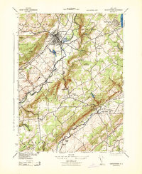
1943 Map of Hackettstown
USGS Topo · Published 1943About this map
Industrial and agricultural life in northwestern New Jersey centers on the Hackettstown hub, where the Musconetcong River draws a clear line between Warren and Morris counties. Local manufacturing is prominently marked by the N J Hosiery Mill, Lackawanna Leather Co, and a Powder Plant on the town's outskirts. The landscape transitions from the developed valley floor to the elevations of Pohatcong Mountain and Schooleys Mountain, with the State Fish Hatchery and Stephens State Park occupying significant riverside tracts.
Find a feature on this map
47 named features on this map. Tap any name to fly to it.
Don’t see what you’re looking for? This feature index may not catch every label — zoom into the map to look around manually.
Map Details
Editions of this 1943 Hackettstown Map
This is the sole edition of this map. No revisions or reprints were ever made.
Other maps of this area

1888 · Hackettstown
USGS Topo · 1:62,500

1888 · Lake Hopatcong
USGS Topo · 1:62,500

1890 · High Bridge
USGS Topo · 1:62,500

1891 · Somerville
USGS Topo · 1:62,500

1893 · Somerville
USGS Topo · 1:62,500

1894 · Hackettstown
USGS Topo · 1:62,500

1894 · Lake Hopatcong
USGS Topo · 1:62,500

1898 · Lake Hopatcong
USGS Topo · 1:62,500

1898 · Hackettstown
USGS Topo · 1:62,500

1898 · High Bridge
USGS Topo · 1:62,500
Featured Places
- Mount Olive, NJ
- Hackettstown, NJ
- Long Valley, Washington Township
- Lebanon Township, NJ
- Washington Township, NJ