1950s Maps of Washington Township, New Jersey
Explore 7 historic maps of Washington Township from the 1950s. These maps offer a rare glimpse into what life looked like during the 1950s — showing old roads, neighborhoods, homes, and landmarks that have changed or disappeared over time.
Whether you're researching your family's past, planning a metal detecting trip, or studying how Washington Township's landscape evolved across the 1950s, these high-resolution maps are a powerful tool for exploring the history of this region.
- Focus on a specific era: All maps on this page are from the 1950s, giving you a focused view of this time period.
- See what’s changed: Compare century-old streets, trails, and buildings to today's modern landscape using overlays and satellite layers.
- Research with precision: Use these maps for genealogy, historical research, land use analysis, or educational projects.
- View, download, or print: Maps are fully viewable online in high resolution, and can be downloaded or printed for your own records.
Start exploring Washington Township's history through authentic maps from the 1950s. This is your window into the past.
Washington Township, NJ maps
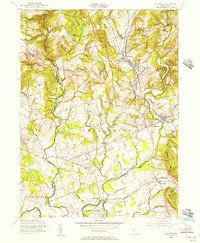
(7)- 1953 Map of Hackettstown, 1955 Print
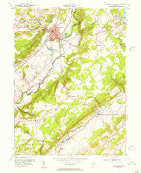 1953 Hackettstown1955 Print · USGSIn the early 1950s, the Musconetcong Valley was a hub of rail activity and collegiate life. Trace the old lines of the Lackawanna Railroad and discover vanished local landmarks like Hackettstown Airfield and the Middle Valley School.6 unique versions available
 - 1954 Map of Washington, 1955 Print
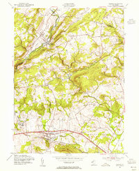
 1954 Washington1955 Print · USGSWarren County in the mid-fifties is characterized by its prominent ridges and a transport network connecting historic valley settlements. Researchers can trace the legacy of the local iron industry near Oxford or explore rail-side communities like Port Colden and Port Murray.6 unique versions available
 - 1954 Map of Califon, 1955 Print
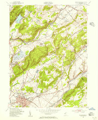
 1954 Califon1955 Print · USGSHunterdon County was a region of river-carved valleys and rail-fed villages in the mid-1950s. Genealogists can trace family names through Fairmount Cem and Union Cem, or locate rural landmarks like McCrea Mills and the State Reformatory.5 unique versions available
 - 1954 Map of Chester, 1956 Print
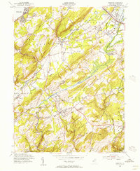 1954 Chester1956 Print · USGSMorris County in the mid-1950s reveals a landscape of established rail lines and early state parkland. Genealogists and historians can trace family-named landmarks and rural outposts like Naughright, Mount Olive, and the Bethany Chapel.8 unique versions available
 - 1954 Map of Gladstone, 1956 Print
 1954 Gladstone1956 Print · USGSMid-century New Jersey comes to life in this detailed survey of the corridor between Oldwick and Far Hills. Genealogists and local historians can trace the foundations of St Johns Academy, find family plots in local Cem sites, and follow the Delaware Lackawanna and Western rail line.5 unique versions available
 - 1956 Map of Newark
 1956 Newark1956 Print · USGSThe industrial heart of the Mid-Atlantic is captured here at the dawn of the highway era, tracing the dense corridors between Newark and Philadelphia. Genealogists and local historians can map the rail networks of the Reading RR or locate mid-century military life at Fort Dix Military Reservation.2 unique versions available
 - 1957 Map of Newark
 1957 Newark1957 Print · USGSThe industrial and military heart of the Mid-Atlantic is mapped during its post-war suburban boom. Genealogists and historians can trace the intricate rail corridors of the Reading Railroad and locate key landmarks from Princeton University to Fort Hancock.
End of results
Showing maps 1-7 of 7
Top cities near Washington Township
- Bridgewater Township historical maps
- Hillsborough Township historical maps
- Mount Olive historical maps
- Rockaway Township historical maps
- Raritan Township historical maps
- Roxbury Township historical maps
See more
Top neighborhoods of Washington Township
- Parker historical maps
- Crestmoore historical maps
- Naughright historical maps
- Scrappy Corner historical maps
- Fairmount historical maps
- Schooleys Mountain historical maps
See more
Frequently asked questions
- What are the different types of historical maps available for Washington Township?
- What is the oldest map of Washington Township?
- Where can I purchase historical maps of Washington Township for my home or office?
- Where can I download high-res historical maps of Washington Township?
- Are there historical topographic maps available for Washington Township?
- Is there historical aerial imagery available for Washington Township?
- Where are historical maps of Washington Township sourced from?