Old Maps of Green Township, New Jersey for Genealogy
Trace your family roots with 49 historic maps of Green Township. These high-res maps reveal old neighborhoods, homesites, landmarks, and streets — helping you uncover where your ancestors lived and how the area evolved over time.
- Explore historic neighborhoods: Identify where your relatives may have lived in the 1800s or 1900s.
- Compare maps over time: Trace the changes in streets, buildings, and landmarks for multi-generational research.
- Perfect for genealogy & ancestry research: Used by family historians and researchers to map out lineage and migration.
These maps are an incredible resource for exploring your personal connection to Green Township's past.
Green Township, NJ maps
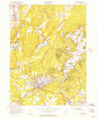
(49)- 1888 Map of Hackettstown
 1888 Hackettstown1888 Print · USGSNorthwestern New Jersey in the late nineteenth century was a hub of transit and industry defined by the Morris Canal and competing rail lines. Genealogists and historians can trace old homesteads and industrial sites near Oxford Furnace, Waterloo, and Hackettstown.
 - 1888 Map of Lake Hopatcong
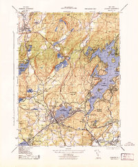
 1888 Lake Hopatcong1888 Print · USGSThe iron and water-power corridors of northern New Jersey are captured here in the late nineteenth century. Trace the industrial footprint of the Morris Canal and major rail lines through early centers like Port Oram, Stanhope, and Dover.
 - 1891 Map of Wallpack
 1891 Wallpack1891 Print · USGSThe Delaware River valley and Kittatinny Mountain ridges define this late nineteenth-century borderland between Pennsylvania and New Jersey. Genealogists can locate historic river crossings like Dingmans Ferry and trace early rail lines including the Paulins Kill Railroad.
 - 1893 Map of Wallpack
 1893 Wallpack1893 Print · USGSThe Delaware River valley and Kittatinny Mountain are captured here during the late nineteenth century, showing a landscape defined by ferries and early rail. You can trace old river crossings like Smiths Ferry or locate the rural post office at Peters Valley Bevans P.O. and the rail stop at Emmons Station.8 unique versions available
 - 1894 Map of Hackettstown
 1894 Hackettstown1894 Print · USGSNorthwestern New Jersey is captured here in the late nineteenth century as a hub of iron production and mountain railroading. Researchers can pinpoint early industrial sites like Oxford Furnace or trace the routes of the Morris and Essex Railroad and Lehigh and Hudson River Railroad.
 - 1894 Map of Lake Hopatcong
 1894 Lake Hopatcong1894 Print · USGSThe New Jersey Highlands are captured here in the 1890s, when the iron-rich hills were still crisscrossed by canal boats and steam locomotives. Researchers can trace the early layout of Lake Hopatcong or locate lost industrial sites near Shippenport and Hacklebarney.
 - 1898 Map of Lake Hopatcong
 1898 Lake Hopatcong1898 Print · USGSNorthwest New Jersey's highland lake country is captured here during a period of intense industrial and resort development. Researchers can trace the path of the Morris Canal, locate historical mining operations at Mine Hill, and explore early lakeside settlements like Mt. Arlington and Landing.2 unique versions available
 - 1898 Map of Hackettstown
 1898 Hackettstown1898 Print · USGSNorthwest New Jersey at the turn of the century is defined by its deep river valleys and the early railroads that pierced its ridge lines. Genealogists and historians can trace the foundations of Hackettstown or locate long-standing landmarks like Swayze Mills and Saxton Falls.2 unique versions available
 - 1900 Map of Raritan
 1900 Raritan1900 Print · USGSNorth Jersey in the late nineteenth century was a complex web of mountain ridges and vital rail corridors. Researchers can trace ancestral routes through old junctions like High Bridge, industrial sites at Mine Hill, and the shores of Lake Hopatcong.
 - 1905 Map of Lake Hopatcong
 1905 Lake Hopatcong1905 Print · USGSNorthern New Jersey during the early twentieth century shows a landscape shaped by iron mining, railroads, and the growing resort culture around Lake Hopatcong. Genealogists and historians can trace family roots through old settlements like Succasunna, the industrial sites at Mine Hill, and the U.S. Navy Powder Depot.3 unique versions available
 - 1905 Map of Raritan
 1905 Raritan1905 Print · USGSNorthern New Jersey's ridges and valleys are meticulously detailed here at the turn of the century. You can trace the complex rail networks of the Lehigh Valley R.R. and locate family landmarks from Swayze Mills to the Powder Depot near Picatinny Peak.2 unique versions available
 - 1905 Map of Hackettstown
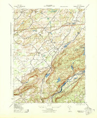
 1905 Hackettstown1905 Print · USGSWarren and Morris Counties at the turn of the century show a landscape defined by industrial transport and river valleys. Researchers can trace the historic Morris Canal and the complex rail networks serving towns like Hackettstown, Vienna, and Oxford.5 unique versions available
 - 1943 Map of Stanhope
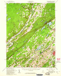
 1943 Stanhope1943 Print · USGSMid-century Sussex and Morris County life is centered here on the busy rail and water corridors of the highlands. Researchers can trace the path of the Morris Canal, locate the Hercules Powder Co works, and explore lakefront landmarks like Bertrand Island.
 - 1943 Map of Tranquility
 1943 Tranquility1943 Print · USGSWarren and Sussex Counties were defined by quiet hamlets and intersecting rail lines in the mid-forties, long before the modern interstate era. Researchers can trace historic family landmarks and rural infrastructure from the Quaker Church to the Delaware Lackawanna and Western RR and the old settlement of Waterloo.
 - 1944 Map of Newark, 1971 Print
 1944 Newark1971 Print · USGSThe industrial corridor from Philadelphia to New York was in a period of massive transition during the mid-forties. Genealogists and researchers can trace the rail lines of the Lehigh Valley RR, locate military installations like Picatinny Arsenal, and explore the early sprawl near Levittown.5 unique versions available
 - 1949 Map of Newark
 1949 Newark1949 Print · USGSThe industrial corridor between Philadelphia and New York comes alive in this post-war survey. Genealogists and historians can trace the massive rail networks of the Reading Railroad and locate major installations like Fort Dix or Picatinny Arsenal.2 unique versions available
 - 1950 Map of Scranton, 1952 Print
 1950 Scranton1952 Print · USGSMid-century Northeast Pennsylvania and the Hudson Valley come alive in this survey of the tri-state region. Genealogists and historians can trace the dense rail networks of the Erie RR and DL&W RR between industrial hubs like Scranton and Wilkes-Barre.
 - 1953 Map of Scranton
 1953 Scranton1953 Print · USGSNortheastern Pennsylvania and the Catskills are shown in great detail during the early fifties, a time when rail lines and river valleys dictated the region's growth. Genealogists and historians can trace the industrial hearts of Scranton and Wilkes-Barre or locate remote landmarks like High Point and Lake Wallenpaupack.
 - 1954 Map of Newton West, 1955 Print
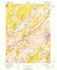 1954 Newton West1955 Print · USGSSussex County transitioned through the mid-fifties as rural farmlands met expanding local centers like Newton. Researchers can trace the dual rail paths of the New York Susquehanna and Western and Lehigh and New England past landmarks like St Pauls Abbey and Swartswood Lake.4 unique versions available
 - 1954 Map of Tranquility, 1956 Print
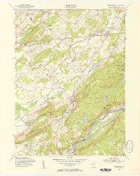 1954 Tranquility1956 Print · USGSNorthern New Jersey highlands in the mid-1950s show a region of mountain ridges and active rail corridors. Local historians can trace the foundations of Allamuchy, Huntsville, and Saxton Falls alongside the Lehigh and Hudson River Railroad.5 unique versions available
 - 1954 Map of Stanhope, 1957 Print
 1954 Stanhope1957 Print · USGSStanhope and the Lake Hopatcong region are shown here in the mid-1950s as the area balanced its rail-industrial roots with growing lakeside recreation. Genealogists and local researchers can locate the Stanhope Union Cem, the Budd Lake Sch, and the winding tracks of the Central RR of New Jersey.5 unique versions available
 - 1954 Map of Dingmans Ferry, 1960 Print
 1954 Dingmans Ferry1960 Print · USGSSussex County, New Jersey, and the Delaware River valley are captured here in the mid-fifties, just as the region’s recreation economy was at its peak. Genealogists and historians can trace the foundations of Stillwater and Branchville, or locate remote landmarks like Wallpack Center and Millbrook.2 unique versions available
 - 1956 Map of Newark
 1956 Newark1956 Print · USGSThe industrial heart of the Mid-Atlantic is captured here at the dawn of the highway era, tracing the dense corridors between Newark and Philadelphia. Genealogists and local historians can map the rail networks of the Reading RR or locate mid-century military life at Fort Dix Military Reservation.2 unique versions available
 - 1957 Map of Newark
 1957 Newark1957 Print · USGSThe industrial and military heart of the Mid-Atlantic is mapped during its post-war suburban boom. Genealogists and historians can trace the intricate rail corridors of the Reading Railroad and locate key landmarks from Princeton University to Fort Hancock.
 - 1959 Map of Scranton
 1959 Scranton1959 Print · USGSThe northern coalfields and the Hudson Valley meet in this mid-century survey of the Pennsylvania and New York borderlands. Genealogists and historians can trace the intricate rail networks of the Erie Railroad and the vast waters of Lake Wallenpaupack.2 unique versions available
Showing maps 1-25 of 49
Top cities near Green Township
- Mount Olive historical maps
- Vernon Township historical maps
- Rockaway Township historical maps
- Roxbury Township historical maps
- Sparta Township historical maps
- Dover historical maps
See more
Top neighborhoods of Green Township
- Brighton historical maps
- Greendell historical maps
- Tranquility historical maps
- Huntsville historical maps
- Huntsburg historical maps
Frequently asked questions
- What are the different types of historical maps available for Green Township?
- What is the oldest map of Green Township?
- Where can I purchase historical maps of Green Township for my home or office?
- Where can I download high-res historical maps of Green Township?
- Are there historical topographic maps available for Green Township?
- Is there historical aerial imagery available for Green Township?
- Where are historical maps of Green Township sourced from?