1900s (20th Century) Maps of Lake Arthur, New Mexico
Explore 9 historic maps of Lake Arthur from the 1900s (20th Century). These maps offer a rare glimpse into what life looked like during the 1900s — showing old roads, neighborhoods, homes, and landmarks that have changed or disappeared over time.
Whether you're researching your family's past, planning a metal detecting trip, or studying how Lake Arthur's landscape evolved across the 1900s, these high-resolution maps are a powerful tool for exploring the history of this region.
- Focus on a specific era: All maps on this page are from the 1900s, giving you a focused view of this time period.
- See what’s changed: Compare century-old streets, trails, and buildings to today's modern landscape using overlays and satellite layers.
- Research with precision: Use these maps for genealogy, historical research, land use analysis, or educational projects.
- View, download, or print: Maps are fully viewable online in high resolution, and can be downloaded or printed for your own records.
Start exploring Lake Arthur's history through authentic maps from the 1900s. This is your window into the past.
Lake Arthur, NM maps
(9)- 1951 Map of Hagerman, 1953 Print
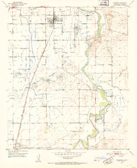 1951 Hagerman1953 Print · USGSAgricultural life in Chaves County flourished in the early fifties as irrigation and rail lines connected the Pecos River valley. Genealogists and local historians can trace family roots through the streets of Hagerman and Lake Arthur, or locate landmarks like Mossman and Hagerman Cemetery.2 unique versions available
 - 1954 Map of Carlsbad, 1963 Print
 1954 Carlsbad1963 Print · USGSSoutheastern New Mexico's desert peaks and river valleys appear in this mid-century study of the borderlands. Researchers can locate vanished sites like Sacramento City, trace the Pecos River reservoirs, and explore Carlsbad Caverns.3 unique versions available
 - 1955 Map of Artesia NE, 1956 Print
 1955 Artesia NE1956 Print · USGSThe high plains of Eddy and Chaves County come alive in the mid-1950s as the river valley meets early oil exploration. Trace the rail-and-river network from Lake Arthur down the Pecos River or locate the remote Oil Well and Oil Tank in the eastern flats.3 unique versions available
 - 1955 Map of Roswell, 1974 Print
 1955 Roswell1974 Print · USGSSoutheastern New Mexico is shown in transition during the mid-fifties, from the Pecos Valley ranching hubs to the high timber of the Sacramento Mountains. Researchers can trace the Atchison Topeka and Santa Fe RR through Roswell and Hagerman or locate the old barracks at Ft Stanton.3 unique versions available
 - 1958 Map of Carlsbad
 1958 Carlsbad1958 Print · USGSSoutheastern New Mexico in the mid-1950s shows a landscape of deep desert basins and high forest ranges during a period of steady ranching and early tourism. Researchers can trace the path of the Atchison Topeka and Santa Fe railroad or find vanished locales like Sacramento City (abandoned) and Whites City.2 unique versions available
 - 1958 Map of Roswell
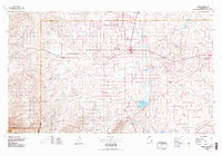
 1958 Roswell1958 Print · USGSThe High Plains and mountain peaks of New Mexico are captured here during the mid-fifties, showing the region before the closure of Walker Air Force Base. Researchers can trace the ranching and rail landscape from Lincoln to the Pecos River valley through Hagerman and Lake Arthur.
 - 1962 Map of Roswell
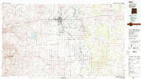
 1962 Roswell1962 Print · USGSSoutheastern New Mexico in the early sixties shows a landscape defined by high mountain peaks and a growing military presence at Roswell. Genealogists and historians can trace the roads connecting Fort Stanton, Capitan, and the Mescalero Apache Indian Reservation.
 - 1978 Map of Artesia, 1979 Print
 1978 Artesia1979 Print · USGSThe Pecos River valley in southeastern New Mexico comes alive in the late seventies, showing the intersection of rail-line agriculture and oil-field growth. Trace the path of the Atchison Topeka and Santa Fe through settlements like Dayton, Espuela, and Lakewood near Lake McMillan.
 - 1979 Map of Roswell
 1979 Roswell1979 Print · USGSThe Pecos River valley and the city of Roswell are shown here in the late seventies as the region balanced aviation growth with agricultural heritage. Trace the transition of local sites like Roswell Industrial Air Center and the Atchison Topeka and Santa Fe rail line.
End of results
Showing maps 1-9 of 9
Top cities near Lake Arthur
Frequently asked questions
- What are the different types of historical maps available for Lake Arthur?
- What is the oldest map of Lake Arthur?
- Where can I purchase historical maps of Lake Arthur for my home or office?
- Where can I download high-res historical maps of Lake Arthur?
- Are there historical topographic maps available for Lake Arthur?
- Is there historical aerial imagery available for Lake Arthur?
- Where are historical maps of Lake Arthur sourced from?