1900s (20th Century) Maps of Milan, New Mexico
Explore 9 historic maps of Milan from the 1900s (20th Century). These maps offer a rare glimpse into what life looked like during the 1900s — showing old roads, neighborhoods, homes, and landmarks that have changed or disappeared over time.
Whether you're researching your family's past, planning a metal detecting trip, or studying how Milan's landscape evolved across the 1900s, these high-resolution maps are a powerful tool for exploring the history of this region.
- Focus on a specific era: All maps on this page are from the 1900s, giving you a focused view of this time period.
- See what’s changed: Compare century-old streets, trails, and buildings to today's modern landscape using overlays and satellite layers.
- Research with precision: Use these maps for genealogy, historical research, land use analysis, or educational projects.
- View, download, or print: Maps are fully viewable online in high resolution, and can be downloaded or printed for your own records.
Start exploring Milan's history through authentic maps from the 1900s. This is your window into the past.
Milan, NM maps
(9)- 1957 Map of Grants, 1959 Print
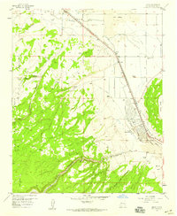
 1957 Grants1959 Print · USGSGrants and the neighboring settlement of Bluewater are shown here in the late fifties, framed by volcanic flows and the rising plateau. Researchers can trace the path of the Atchison Topeka and Santa Fe railroad through town and locate early local infrastructure like the High Sch and various mines.3 unique versions available
 - 1957 Map of Milan, 1959 Print
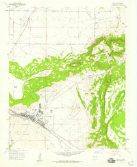
 1957 Milan1959 Print · USGSThe high-desert corridor of Valencia County is captured here in the late fifties as rail and road travel transformed the region. Genealogists and historians can trace family operations like the Harding Ranch or locate the local Bluewater Cemetery and the Drive-in Theater.3 unique versions available
 - 1958 Map of Albuquerque
 1958 Albuquerque1958 Print · USGSAlbuquerque and the surrounding high desert are captured here during a period of massive federal expansion and postwar growth. Researchers can trace the development of Kirtland Air Force Base, find ancestral homes in Pueblo de Santa Ana, or locate industrial sites like the Jackpile Mine.
 - 1962 Map of Albuquerque
 1962 Albuquerque1962 Print · USGSAlbuquerque and the surrounding high desert are captured here in the early 1960s during a period of intense mineral and military growth. Genealogists and historians can locate early schools like the Pueblo Pintado School, major industrial sites like the Jackpile Mine, and the sprawling Kirtland Air Force Base.
 - 1963 Map of Albuquerque, 1965 Print
 1963 Albuquerque1965 Print · USGSMid-century New Mexico unfolds across this map, showcasing the intersection of ancient pueblos, modern military bases, and historic mining districts. Trace family roots and local history through the Ortiz Mine, Seven Lakes Trading Post, and Alameda.3 unique versions available
 - 1978 Map of Grants
 1978 Grants1978 Print · USGSWest-Central New Mexico is captured here in the late seventies as uranium mining and the railroad shaped the high desert landscape. Genealogists and historians can trace settlements from Grants to Laguna, including the Jackpile Mine and Acomita West Village.2 unique versions available
 - 1983 Map of Albuquerque, 1984 Print
 1983 Albuquerque1984 Print · USGSCentral New Mexico in the early eighties shows a landscape where ancient pueblos and modern aerospace hubs meet. Trace the routes of the Atchison Topeka and Santa Fe RR or locate landmarks like Kirtland Air Force Base, Madrid, and the Sandia Mountains.
 - 1995 Map of Milan, 1998 Print
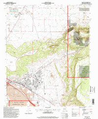
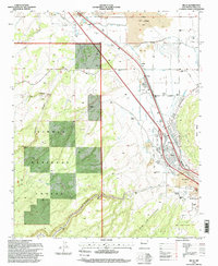 1995 Milan1998 Print · USGSThe lava-scarred terrain around Milan and Toltec is captured here in the mid-1990s, showcasing a landscape where ranching meets volcanic geology. Genealogists and historians can trace family properties like Schneemann Ranch, locate the Bluewater Cemetery, and see the early layout of the Grants Municipal Airport.
 - 1995 Map of Grants, 1998 Print
 1995 Grants1998 Print · USGSGrants and the surrounding high desert are captured here in the mid-1990s, showcasing a landscape defined by volcanic geology and industrial growth. Researchers can trace the rail corridor of the Atchison Topeka and Santa Fe or locate the Homestake Mill and State Prison.
End of results
Showing maps 1-9 of 9
Top cities near Milan
Frequently asked questions
- What are the different types of historical maps available for Milan?
- What is the oldest map of Milan?
- Where can I purchase historical maps of Milan for my home or office?
- Where can I download high-res historical maps of Milan?
- Are there historical topographic maps available for Milan?
- Is there historical aerial imagery available for Milan?
- Where are historical maps of Milan sourced from?