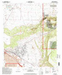
1995 Map of Grants
USGS Topo · Published 1998About this map
The Grants township sits at the intersection of industrial history and volcanic geology, centered near the Rio San Jose and the Atchison Topeka and Santa Fe railroad corridor. The landscape is defined by the massive basaltic flows of Lava and The Malpais, which dominate the southwestern portion of the map within the El Malpais National Conservation Area. To the north, the industrial legacy of the region is evident at the Homestake Mill and numerous mine and Pumice extraction sites throughout Cibola National Forest.
Find a feature on this map
34 named features on this map. Tap any name to fly to it.
Don’t see what you’re looking for? This feature index may not catch every label — zoom into the map to look around manually.
Map Details
Editions of this 1995 Grants Map
This is the sole edition of this map. No revisions or reprints were ever made.
Other maps of this area

1883 · Mt. Taylor
USGS Topo · 1:250,000

1886 · Mt. Taylor
USGS Topo · 1:250,000

1892 · Mt. Taylor
USGS Topo · 1:250,000

1899 · Mt. Taylor
USGS Topo · 1:250,000

1957 · San Rafael
USGS Topo · 1:24,000

1957 · Lobo Springs
USGS Topo · 1:24,000

1957 · Dos Lomas
USGS Topo · 1:24,000

1957 · Grants SE
USGS Topo · 1:24,000

1957 · Bluewater
USGS Topo · 1:24,000

1957 · Mc Cartys
USGS Topo · 1:24,000