
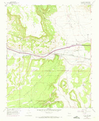
1957 Map of Mc Cartys
USGS Topo · Published 1959About this map
McCartys and the Santa Maria Mission anchor this mid-century valley landscape, situated along the Rio San Jose and the Atchison Topeka and Santa Fe railroad. Much of the terrain is defined by the high plateaus of Horace Mesa and Mc Carty Mesa, which overlook the Acoma Indian Reservation. The presence of an Abandoned Airfield and the McCartys Siding indicates the importance of transportation and infrastructure within the Acoma Pueblo Grant. Beyond the primary settlement, the map reveals isolated agricultural outposts like Chief Rancho and Lane Ranch, and various springs such as Lobo Springs and Lane Spring that were vital for sustaining life in this arid environment. The intricate canyon systems, including Tatoya Canyon and Cañon del Conejo, illustrate a complex drainage network leading into the central river valley.
Find a feature on this map
26 named features on this map. Tap any name to fly to it.
Don’t see what you’re looking for? This feature index may not catch every label — zoom into the map to look around manually.
Map Details
Editions of this 1957 Mc Cartys Map
2 editions found
Other maps of this area

1883 · Mt. Taylor
USGS Topo · 1:250,000

1886 · Mt. Taylor
USGS Topo · 1:250,000

1892 · Mt. Taylor
USGS Topo · 1:250,000

1899 · Mt. Taylor
USGS Topo · 1:250,000

1917 · Broom Mountain
USGS Topo · 1:125,000

1954 · Socorro
USGS Topo · 1:250,000

1957 · Lobo Springs
USGS Topo · 1:24,000

1957 · Mount Taylor
USGS Topo · 1:24,000

1957 · Grants SE
USGS Topo · 1:24,000

1957 · Cubero
USGS Topo · 1:24,000