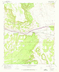
1957 Map of Mc Cartys
USGS Topo · Published 1973About this map
The Rio San Jose corridor defines the landscape of the Acoma Pueblo Grant, where the Atchison Topeka and Santa Fe railroad parallels the historic route of Highway 66. This mid-century survey illustrates the vital infrastructure supporting the McCartys settlement, including the Santa Maria Mission and the nearby McCartys Siding. High mesas such as Horace Mesa and Mc Carty Mesa rise sharply from the canyon floors, carved by drainage systems like Tafoya Canyon and Cañon Largo.
Find a feature on this map
33 named features on this map. Tap any name to fly to it.
Don’t see what you’re looking for? This feature index may not catch every label — zoom into the map to look around manually.
Map Details
Editions of this 1957 Mc Cartys Map
2 editions found
Other maps of this area

1883 · Mt. Taylor
USGS Topo · 1:250,000

1886 · Mt. Taylor
USGS Topo · 1:250,000

1892 · Mt. Taylor
USGS Topo · 1:250,000

1899 · Mt. Taylor
USGS Topo · 1:250,000

1917 · Broom Mountain
USGS Topo · 1:125,000

1954 · Socorro
USGS Topo · 1:250,000

1957 · Lobo Springs
USGS Topo · 1:24,000

1957 · Mount Taylor
USGS Topo · 1:24,000

1957 · Grants SE
USGS Topo · 1:24,000

1957 · Mc Cartys
USGS Topo · 1:24,000