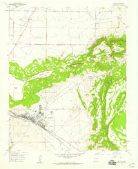
1957 Map of Grants
USGS Topo · Published 1959About this map
Grants sits at the base of a complex volcanic and sedimentary landscape, serving as a vital stop along the Atchison Topeka and Santa Fe railroad in the late 1950s. The settlement pattern is defined by the valley of the Rio San Jose, which separates the town from the stark, dark expanse of The Malpais and its Lava flows to the south. To the north and east, the dramatic elevation of Grants Ridge and Horace Mesa dominates the horizon, with the latter bordering the Acoma Pueblo Indian Land. This survey captures the town during a period of industrial activity, evidenced by a Sewage Disposal plant and a local High Sch. The presence of several mines and a Gravel Pit near Lobo Canyon suggests the economic importance of the surrounding geology during this era of New Mexico's development.
Find a feature on this map
26 named features on this map. Tap any name to fly to it.
Don’t see what you’re looking for? This feature index may not catch every label — zoom into the map to look around manually.
Map Details
Editions of this 1957 Grants Map
Other maps of this area

1883 · Mt. Taylor
USGS Topo · 1:250,000

1886 · Mt. Taylor
USGS Topo · 1:250,000

1892 · Mt. Taylor
USGS Topo · 1:250,000

1899 · Mt. Taylor
USGS Topo · 1:250,000

1957 · San Rafael
USGS Topo · 1:24,000

1957 · Lobo Springs
USGS Topo · 1:24,000

1957 · Dos Lomas
USGS Topo · 1:24,000

1957 · Grants SE
USGS Topo · 1:24,000

1957 · Bluewater
USGS Topo · 1:24,000

1957 · Mc Cartys
USGS Topo · 1:24,000