1940s Maps of Santo Tomas, New Mexico
Explore 1 historic maps of Santo Tomas from the 1940s. These maps offer a rare glimpse into what life looked like during the 1940s — showing old roads, neighborhoods, homes, and landmarks that have changed or disappeared over time.
Whether you're researching your family's past, planning a metal detecting trip, or studying how Santo Tomas's landscape evolved across the 1940s, these high-resolution maps are a powerful tool for exploring the history of this region.
- Focus on a specific era: All maps on this page are from the 1940s, giving you a focused view of this time period.
- See what’s changed: Compare century-old streets, trails, and buildings to today's modern landscape using overlays and satellite layers.
- Research with precision: Use these maps for genealogy, historical research, land use analysis, or educational projects.
- View, download, or print: Maps are fully viewable online in high resolution, and can be downloaded or printed for your own records.
Start exploring Santo Tomas's history through authentic maps from the 1940s. This is your window into the past.
Santo Tomas, NM maps
(1)- 1943 Map of La Mesa
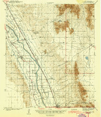 1943 La Mesa1943 Print · USGSThe Mesilla Valley during the early years of the war reveals a complex system of desert irrigation and historic land grants. Genealogists can trace family roots through numerous local landmarks, including the Memorial Ridge Cem, San Luis Ch, and the Beasley Homestead.2 unique versions available
End of results
Showing maps 1-1 of 1
Top cities near Santo Tomas
- El Paso historical maps
- Las Cruces historical maps
- Anthony historical maps
- Anthony, NM historical maps
- Anthony historical maps
- Vinton historical maps
See more
Frequently asked questions
- What are the different types of historical maps available for Santo Tomas?
- What is the oldest map of Santo Tomas?
- Where can I purchase historical maps of Santo Tomas for my home or office?
- Where can I download high-res historical maps of Santo Tomas?
- Are there historical topographic maps available for Santo Tomas?
- Is there historical aerial imagery available for Santo Tomas?
- Where are historical maps of Santo Tomas sourced from?