1960s Maps of Deming, New Mexico
Explore 4 historic maps of Deming from the 1960s. These maps offer a rare glimpse into what life looked like during the 1960s — showing old roads, neighborhoods, homes, and landmarks that have changed or disappeared over time.
Whether you're researching your family's past, planning a metal detecting trip, or studying how Deming's landscape evolved across the 1960s, these high-resolution maps are a powerful tool for exploring the history of this region.
- Focus on a specific era: All maps on this page are from the 1960s, giving you a focused view of this time period.
- See what’s changed: Compare century-old streets, trails, and buildings to today's modern landscape using overlays and satellite layers.
- Research with precision: Use these maps for genealogy, historical research, land use analysis, or educational projects.
- View, download, or print: Maps are fully viewable online in high resolution, and can be downloaded or printed for your own records.
Start exploring Deming's history through authentic maps from the 1960s. This is your window into the past.
Deming, NM maps
(4)- 1964 Map of Deming West, 1967 Print
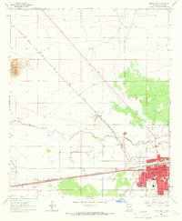 1964 Deming West1967 Print · USGSDeming stood as a bustling rail and desert hub in the 1960s, marked by the intersection of two major transcontinental railroads. Researchers can trace the town's mid-century growth through local landmarks like Holy Cross Cem, the Concentrating Plant at Peruhill, and Mimbres Mem Hospital.
 - 1965 Map of Deming East, 1966 Print
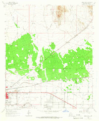 1965 Deming East1966 Print · USGSDeming sits at a vital railroad junction in the mid-1960s, framed by the desert drainage of the Mimbres River. Genealogists and local historians can trace the town's footprint through the Mountain View Cem, the Southwestern New Mexico State Fairgrounds, and the old Mirage station.2 unique versions available
 - 1965 Map of Capitol Dome, 1967 Print
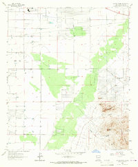 1965 Capitol Dome1967 Print · USGSThe high desert of Luna County is captured in the mid-1960s when ranching and mining defined the foothills of the Florida Mountains. Researchers can trace old livestock operations at Spanish Stirrup Ranch and locate historical workings at the Copper Queen Mine.2 unique versions available
 - 1965 Map of Bowlin Ranch, 1967 Print
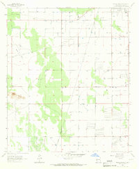 1965 Bowlin Ranch1967 Print · USGSIn the mid-1960s, this Luna County landscape was a quiet expanse of New Mexico ranchland and desert infrastructure. Genealogists and historians can trace the foundations of the Sunshine Sch, the isolated Bowlin Ranch, and the path of the Hermanas Grade.
End of results
Showing maps 1-4 of 4
Top neighborhoods of Deming
Frequently asked questions
- What are the different types of historical maps available for Deming?
- What is the oldest map of Deming?
- Where can I purchase historical maps of Deming for my home or office?
- Where can I download high-res historical maps of Deming?
- Are there historical topographic maps available for Deming?
- Is there historical aerial imagery available for Deming?
- Where are historical maps of Deming sourced from?