
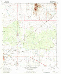
1965 Map of Deming East
USGS Topo · Published 1966About this map
Deming serves as the focal point of this mid-1960s survey, where the convergence of the Atchison Topeka and Santa Fe and the Southern Pacific railroads underscores its historical role as a transportation hub. The landscape is defined by the ephemeral Mimbres River and the rugged southern extent of the Cooks Range to the north. Social and community life are well-documented through landmarks like the Southwestern New Mexico State Fairgrounds, the Rio Mimbres Country Club, and the Mountain View Cem. Outside the main settlement, the map traces the drainage patterns of China Draw and Starvation Draw, alongside isolated outposts like Mirage. Cultural artifacts of the era, such as the Rio Mimbres Drive-in Theater and the local Airport, provide a specific look at the town's mid-century expansion and infrastructure.
Find a feature on this map
25 named features on this map. Tap any name to fly to it.
Don’t see what you’re looking for? This feature index may not catch every label — zoom into the map to look around manually.
Map Details
Editions of this 1965 Deming East Map
2 editions found
Other maps of this area

1899 · Deming
USGS Topo · 1:125,000

1915 · Deming
USGS Topo · 1:125,000

1955 · Las Cruces
USGS Topo · 1:250,000

1958 · Las Cruces
USGS Topo · 1:250,000

1964 · Goat Ridge
USGS Topo · 1:24,000

1964 · Florida
USGS Topo · 1:24,000

1964 · Deming West
USGS Topo · 1:24,000

1964 · Massacre Peak
USGS Topo · 1:24,000

1964 · Florida Gap
USGS Topo · 1:24,000

1965 · Carne
USGS Topo · 1:24,000