1940s Maps of Alvarado, New Mexico
Explore 3 historic maps of Alvarado from the 1940s. These maps offer a rare glimpse into what life looked like during the 1940s — showing old roads, neighborhoods, homes, and landmarks that have changed or disappeared over time.
Whether you're researching your family's past, planning a metal detecting trip, or studying how Alvarado's landscape evolved across the 1940s, these high-resolution maps are a powerful tool for exploring the history of this region.
- Focus on a specific era: All maps on this page are from the 1940s, giving you a focused view of this time period.
- See what’s changed: Compare century-old streets, trails, and buildings to today's modern landscape using overlays and satellite layers.
- Research with precision: Use these maps for genealogy, historical research, land use analysis, or educational projects.
- View, download, or print: Maps are fully viewable online in high resolution, and can be downloaded or printed for your own records.
Start exploring Alvarado's history through authentic maps from the 1940s. This is your window into the past.
Alvarado, NM maps
(3)- 1941 Map of Desert, 1961 Print
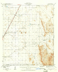 1941 Desert1961 Print · USGSThe arid borderlands of Otero County and the New Mexico-Texas line are captured here in the early 1940s, when the railroad was the primary artery of life. Genealogists and historians can trace old ranching outposts like McCracken Ranch and Davis Ranch along the Southern Pacific tracks.2 unique versions available
 - 1943 Map of Desert
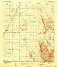 1943 Desert1943 Print · USGSOtero County ranching and rail operations are captured here during the early years of the war. Genealogists and historians can trace family landmarks and water sources like the McCracken Ranch, Davis Ranch, and the isolated Desert station along the Southern Pacific.
 - 1948 Map of Desert
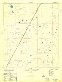 1948 Desert1948 Print · USGSThe Tularosa Valley in the late 1940s was a landscape of military expansion and railway transit. Researchers can trace the path of the Southern Pacific railroad through Fort Bliss Military Reservation and find old stops at Desert and Alvarado.
End of results
Showing maps 1-3 of 3
Top cities near Alvarado
Frequently asked questions
- What are the different types of historical maps available for Alvarado?
- What is the oldest map of Alvarado?
- Where can I purchase historical maps of Alvarado for my home or office?
- Where can I download high-res historical maps of Alvarado?
- Are there historical topographic maps available for Alvarado?
- Is there historical aerial imagery available for Alvarado?
- Where are historical maps of Alvarado sourced from?