1900s (20th Century) Maps of Old Wright Place, New Mexico
Explore 5 historic maps of Old Wright Place from the 1900s (20th Century). These maps offer a rare glimpse into what life looked like during the 1900s — showing old roads, neighborhoods, homes, and landmarks that have changed or disappeared over time.
Whether you're researching your family's past, planning a metal detecting trip, or studying how Old Wright Place's landscape evolved across the 1900s, these high-resolution maps are a powerful tool for exploring the history of this region.
- Focus on a specific era: All maps on this page are from the 1900s, giving you a focused view of this time period.
- See what’s changed: Compare century-old streets, trails, and buildings to today's modern landscape using overlays and satellite layers.
- Research with precision: Use these maps for genealogy, historical research, land use analysis, or educational projects.
- View, download, or print: Maps are fully viewable online in high resolution, and can be downloaded or printed for your own records.
Start exploring Old Wright Place's history through authentic maps from the 1900s. This is your window into the past.
Old Wright Place, NM maps
(5)- 1943 Map of Pendejo Wash
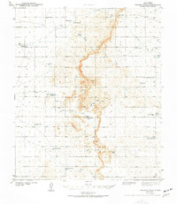 1943 Pendejo Wash1943 Print · USGSOtero County ranch lands are documented here during the early 1940s, showing a landscape defined by desert water management. Genealogists and historians can trace family-named sites like the Old Wright Place and vital water sources such as Wilde Well and Hay Meadow Tank.2 unique versions available
 - 1954 Map of Carlsbad, 1963 Print
 1954 Carlsbad1963 Print · USGSSoutheastern New Mexico's desert peaks and river valleys appear in this mid-century study of the borderlands. Researchers can locate vanished sites like Sacramento City, trace the Pecos River reservoirs, and explore Carlsbad Caverns.3 unique versions available
 - 1958 Map of Carlsbad
 1958 Carlsbad1958 Print · USGSSoutheastern New Mexico in the mid-1950s shows a landscape of deep desert basins and high forest ranges during a period of steady ranching and early tourism. Researchers can trace the path of the Atchison Topeka and Santa Fe railroad or find vanished locales like Sacramento City (abandoned) and Whites City.2 unique versions available
 - 1979 Map of Crow Flats
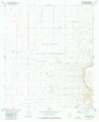
 1979 Crow Flats1979 Print · USGSThe high desert borderlands of Otero County and West Texas are captured here during the late seventies, showing a landscape of remote ranches and military ranges. Researchers can trace land use through the Old Wright Place, Alton Jones Ranch, and the Runyan Landing Field.2 unique versions available
 - 1980 Map of Wilde Tank
 1980 Wilde Tank1980 Print · USGSThe McGregor Range in southern New Mexico is captured here in the early 1980s, showcasing a landscape of military corridors and ranching remnants. Researchers can trace the water history of the region through catchments like Wilde Tank and the Old Wright Place.
End of results
Showing maps 1-5 of 5
Top cities near Old Wright Place
Frequently asked questions
- What are the different types of historical maps available for Old Wright Place?
- What is the oldest map of Old Wright Place?
- Where can I purchase historical maps of Old Wright Place for my home or office?
- Where can I download high-res historical maps of Old Wright Place?
- Are there historical topographic maps available for Old Wright Place?
- Is there historical aerial imagery available for Old Wright Place?
- Where are historical maps of Old Wright Place sourced from?