
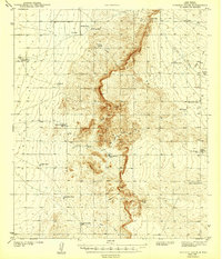
1943 Map of Pendejo Wash
USGS Topo · Published 1943About this map
Pendejo Wash snakes through this high desert landscape, defining a region characterized by sparse settlements and a complex water management system during the early 1940s. The map reveals the critical importance of water in this arid environment, marked by a network of tanks and wells named for local families and early development efforts, such as the CCC Tank and the Old Wright Place. Cattle ranching infrastructure is evident throughout the terrain, with specialized features like the Mare Pasture Tub and Herd Pasture Tub located near the eastern draws.
Find a feature on this map
28 named features on this map. Tap any name to fly to it.
Don’t see what you’re looking for? This feature index may not catch every label — zoom into the map to look around manually.
Map Details
Editions of this 1943 Pendejo Wash Map
2 editions found
Other maps of this area

1916 · Point Of Sands
USGS Topo · 1:125,000

1940 · Bassett Lake
USGS Topo · 1:62,500

1940 · Orogrande
USGS Topo · 1:62,500

1941 · Desert
USGS Topo · 1:62,500

1943 · Desert
USGS Topo · 1:62,500

1943 · Bassett Lake
USGS Topo · 1:62,500

1943 · Orogrande
USGS Topo · 1:62,500

1947 · Desert NE
USGS Topo · 1:24,000

1947 · Orogrande North
USGS Topo · 1:24,000
1948 · Orogrande South
USGS Topo · 1:24,000