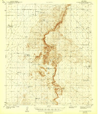
1943 Map of Pendejo Wash
USGS Topo · Published 1943About this map
The Tularosa Valley landscape of the early 1940s is defined here by a network of water management features essential for high-desert ranching. Surveyed just before the expansion of military testing grounds in the region, this map documents the scattered infrastructure of the Old Wright Place and Mesa Horse Camp. The terrain is carved by the winding Pendejo Wash and deep incisions like Rough Canyon and Hay Meadow Canyon. The survival of livestock in this arid environment is evidenced by the density of named water points, including the Hay Meadow Tank, Little Crockett Tank, and the End of Line Tank. These labels reveal a system of grazing boundaries and movement, from the Mare Pasture Tub to the Herd Pasture Tub, capturing a specific moment in New Mexico's pastoral history.
Find a feature on this map
28 named features on this map. Tap any name to fly to it.
Don’t see what you’re looking for? This feature index may not catch every label — zoom into the map to look around manually.
Map Details
Editions of this 1943 Pendejo Wash Map
2 editions found
Other maps of this area

1916 · Point Of Sands
USGS Topo · 1:125,000

1940 · Bassett Lake
USGS Topo · 1:62,500

1940 · Orogrande
USGS Topo · 1:62,500

1941 · Desert
USGS Topo · 1:62,500

1943 · Pendejo Wash
USGS Topo · 1:62,500

1943 · Desert
USGS Topo · 1:62,500

1943 · Bassett Lake
USGS Topo · 1:62,500

1943 · Orogrande
USGS Topo · 1:62,500

1947 · Desert NE
USGS Topo · 1:24,000

1947 · Orogrande North
USGS Topo · 1:24,000