1980s Maps of Tularosa, New Mexico
Explore 4 historic maps of Tularosa from the 1980s. These maps offer a rare glimpse into what life looked like during the 1980s — showing old roads, neighborhoods, homes, and landmarks that have changed or disappeared over time.
Whether you're researching your family's past, planning a metal detecting trip, or studying how Tularosa's landscape evolved across the 1980s, these high-resolution maps are a powerful tool for exploring the history of this region.
- Focus on a specific era: All maps on this page are from the 1980s, giving you a focused view of this time period.
- See what’s changed: Compare century-old streets, trails, and buildings to today's modern landscape using overlays and satellite layers.
- Research with precision: Use these maps for genealogy, historical research, land use analysis, or educational projects.
- View, download, or print: Maps are fully viewable online in high resolution, and can be downloaded or printed for your own records.
Start exploring Tularosa's history through authentic maps from the 1980s. This is your window into the past.
Tularosa, NM maps
(4)- 1981 Map of Tularosa
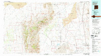 1981 Tularosa1981 Print · USGSThe high-desert basin around Tularosa is captured here in the early eighties as a hub of military and rail activity. Trace the Southern Pacific line past Three Rivers or explore the vast White Sands Missile Range.2 unique versions available
 - 1982 Map of Sabinata Flat
 1982 Sabinata Flat1982 Print · USGSThe Otero County backcountry in the early eighties reveals a landscape shaped by water management and high-desert ranching. Genealogists and historians can trace family-named landmarks like Wallenberg Spring, Whitmore Spring, and the School Section Windmill.
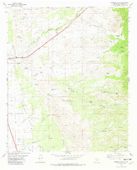
 - 1982 Map of Tularosa
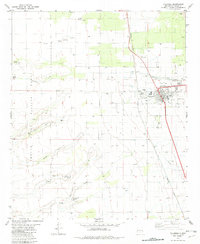 1982 Tularosa1982 Print · USGSTularosa and its high desert surroundings are captured here in the early eighties, showing the village at the edge of the White Sands Missile Range. Genealogists and historians can trace local family landmarks and infrastructure including Aguilar Well, the Cem, and the Tularosa Ditch.
 - 1984 Map of Ruidoso
 1984 Ruidoso1984 Print · USGSThe high country of the Sierra Blanca and the Lincoln National Forest are captured here in the mid-eighties as tourism and traditional land use converged. Local historians can trace the Old Military Reservation Boundary, find historic workings like the Parsons Mine, or locate small communities such as Glencoe and Whitetail.
End of results
Showing maps 1-4 of 4
Top cities near Tularosa
- Alamogordo historical maps
- Boles Acres historical maps
- Alamorosa historical maps
- High Rolls historical maps
Frequently asked questions
- What are the different types of historical maps available for Tularosa?
- What is the oldest map of Tularosa?
- Where can I purchase historical maps of Tularosa for my home or office?
- Where can I download high-res historical maps of Tularosa?
- Are there historical topographic maps available for Tularosa?
- Is there historical aerial imagery available for Tularosa?
- Where are historical maps of Tularosa sourced from?